West Wallsend
| West Wallsend Greater Newcastle, New South Wales | |||||||||||||||
|---|---|---|---|---|---|---|---|---|---|---|---|---|---|---|---|
| Coordinates | 32°53′53″S 151°35′6″E / 32.89806°S 151.58500°E | ||||||||||||||
| Population | 2,240 (2016 census)[1] | ||||||||||||||
| • Density | 1,067/km2 (2,760/sq mi) | ||||||||||||||
| Established | 1860s | ||||||||||||||
| Postcode(s) | 2286 | ||||||||||||||
| Area | 2.1 km2 (0.8 sq mi) | ||||||||||||||
| Location | |||||||||||||||
| LGA(s) | City of Lake Macquarie | ||||||||||||||
| Parish | Teralba | ||||||||||||||
| State electorate(s) | Cessnock | ||||||||||||||
| Federal division(s) | Hunter | ||||||||||||||
| |||||||||||||||
West Wallsend is a suburb and small town in the City of Lake Macquarie, Greater Newcastle in New South Wales, Australia. It is near the Sydney-Newcastle Freeway and the western suburbs of Newcastle.
History
The Awabakal are the traditional people of this area.[2]
Coal and railways

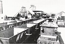
West Wallsend's origins are in coal mining, the main concern being West Wallsend Colliery, from whose boundaries the old town grew. The West Wallsend Coal Company was formed in 1885 with a capital of £90,000 sterling. It secured 2,972 acres (12.03 km2) of freehold land at and around where the township now stands. A shaft of 492 feet (150.0 m) in depth serviced the Borehole seam of almost 5 feet (1.5 m) in thickness.
The coal was shipped by the West Wallsend Coal Company's private railway[3] (which later had several branch line extensions to Seahampton, Fairley, and Killingworth) via Cockle Creek junction onto the government's Main North railway line. An Act of Parliament was passed on 27 August 1886, for the construction of the line and an Amendment passed on 13 July 1887 permitted its connection to the government system. The original line had cost over £16,000 pounds sterling, and at Cockle Creek there were seven sets of sidings to handle the output of the collieries which used the line.[4]
At the time of the opening, on 3 July 1888, it was estimated West Wallsend Colliery would produce up to 200,000 tons of coal a year. In 1895 Caledonian Collieries Limited purchased the company, its collieries, and the railway.
During the industry slump in 1923 it was announced that West Wallsend Colliery would close, raising questions in the New South Wales Legislative Assembly. Regardless of massive reserves, the mine closed on 14 September 1923, 5,376,410 tons of coal having been extracted in its relatively short period of operations – 35 years.
A passenger service also once operated between Cockle Creek and West Wallsend, the latter having a fully staffed station where tickets could be purchased to anywhere in the State which had a railway connection. The last passenger service to West Wallsend ran on 13 January 1930, and the line between Seahampton, West Wallsend, and the Fairley (Seaham No.2 Colliery) Junction closed on 26 November 1938. When Seaham No.2 closed in 1945 the only portion of the railway which continued in use, until 1962, was to Killingworth.
One mine still operates in the district[5] but its coal is shipped by road. The mine's owners have announced that it will be closed in 2016 for economic reasons.[6]
Transport
In the early years of the 20th century, a steam tram service operated from West Wallsend via Young Wallsend to Wallsend where there was a large shopping district and where it also connected with the electric trams which ran into Newcastle.
Education
A primary school was opened in November 1889.[7] West Wallsend High School opened in 1962.[8]
Politics
West Wallsend is located in the federal Division of Charlton, which elects one member to the Australian House of Representatives. The current member, 2013 Federal Election, is Australian Labor Party member Pat Conroy. At state level, after a redistribution in 2006, West Wallsend moved from the Lake Macquarie electorate to the Cessnock electorate. The current State Member is Australian Labor Party member Clayton Barr.
The booth at West Wallsend is considered very safe for the Labor Party.
|
|
| ||||||||||||||||||||||||||||||||||||||||||||||||||||||
|
|
| ||||||||||||||||||||||||||||||||||||||||||||||||||||||
See also
References
- ^ Australian Bureau of Statistics (27 June 2017). "West Wallsend (State Suburb)". 2016 Census QuickStats. Retrieved 9 February 2018.
- ^ "Aboriginal and Torres Strait Islander people". Lake Macquarie City Council. Retrieved 8 September 2020.
- ^ The Railways and Collieries of the West Wallsend District Andrews, B.R. Australian Railway Historical Society Bulletin, April; May 1975; pp. 77–93, 109–123
- ^ Newcastle Morning Herald, 26 November 1889.
- ^ "Macquarie Coal".
- ^ "Glencore to close Australian West Wallsend coal mine in 2016".
- ^ "West Wallsend".
- ^ "West Wallsend High School looks back in time for 50th birthday celebrations". 10 March 2014.
- Neath Mount Sugarloaf – Book 2, West Wallsend Public School Centenary Committee, 1988, ISBN 0-7316-3401-2
External links
- History of West Wallsend (Lake Macquarie City Library)

