Westford (CDP), New York
Westford, New York | |
|---|---|
| Coordinates: 42°39′1″N 74°47′50″W / 42.65028°N 74.79722°W | |
| Country | United States |
| State | New York |
| County | Otsego |
| Town | Westford |
| Area | |
| • Total | 1.65 sq mi (4.26 km2) |
| • Land | 1.65 sq mi (4.26 km2) |
| • Water | 0.00 sq mi (0.00 km2) |
| Elevation | 1,563 ft (476 m) |
| Population (2020) | |
| • Total | 145 |
| • Density | 88.15/sq mi (34.04/km2) |
| Time zone | UTC-5 (Eastern (EST)) |
| • Summer (DST) | UTC-4 (EDT) |
| ZIP Codes | |
| Area code | 607 |
| FIPS code | 36-79961 |
| GNIS feature ID | 2804625[2] |
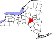
Westford is a census-designated place (CDP) and the primary hamlet in the town of Westford, Otsego County, New York, United States. It was first listed as a CDP prior to the 2020 census.[2]
The community is in eastern Otsego County, slightly north of the center of the town of Westford. It is in the valley of Elk Creek, 8 miles (13 km) north of Schenevus, 6 miles (10 km) northwest of Worcester, and 10 miles (16 km) by road southeast of Cooperstown.
Demographics
| Census | Pop. | Note | %± |
|---|---|---|---|
| 2020 | 145 | — | |
| U.S. Decennial Census[3] | |||
References
- ^ "ArcGIS REST Services Directory". United States Census Bureau. Retrieved September 20, 2022.
- ^ a b "Westford Census Designated Place". Geographic Names Information System. United States Geological Survey, United States Department of the Interior.
- ^ "Census of Population and Housing". Census.gov. Retrieved June 4, 2016.


