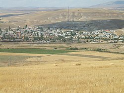
Çetinkaya, Kangal
Çetinkaya | |
|---|---|
Village | |
 A view from the village | |
| Coordinates: 39°15′01″N 37°36′25″E / 39.2504°N 37.6070°E | |
| Country | |
| Province | Sivas Province |
| District | Kangal |
| Government | |
| • Mayor | Gazi Şentürk (AKP) |
| Elevation | 1,432 m (4,698 ft) |
| Population (2016[1]) | |
| • Total | 1,205 |
| Time zone | UTC+3 (FET) |
| Website | Çetinkaya Belediyesi |
Çetinkaya is a village in the Kangal district of the Sivas Province in Turkey. It is located along the Ankara-Kars railway and is near the Çetinkaya junction, where the Çetinkaya-Malatya railway diverges south. As of 2016, Çetinkaya has a population of 1,205.[1] Between 1960 and 2011, the population was in a constant drop from about 4,000 inhabitants in 1960 to 1,477 inhabitants in 2011, a 63% decrease. Due to its population decrease, the town was relegated to a village in the early 2010s.[2]
The village is located just north of the D.260 state highway and Çetinkaya station is serviced by intercity trains from Ankara[3][4][5] (temporarily Irmak) to Kars,[3] Kurtalan,[4] and Tatvan,[5] as well as regional trains from Sivas[6] to Divriği.[6]
References
- ^ a b Population page
- ^ "Çetinkaya belediyesi". yerelnet.org.tr. Retrieved 29 October 2017.
- ^ a b "Doğu Ekspresi". tcddseferleri.com. Retrieved 29 October 2017.
- ^ a b "Güney Kurtalan Ekspresi". tcddseferleri.com. Retrieved 29 October 2017.
- ^ a b "Van Gölü Ekspresi". tcddseferleri.com. Retrieved 29 October 2017.
- ^ a b "Sivas Divriği Treni". seyhat.railturkey.org. Retrieved 29 October 2017.

