Újléta
Appearance
Újléta | |
|---|---|
 | |
| Coordinates: 47°28′N 21°53′E / 47.467°N 21.883°E | |
| Country | |
| County | Hajdú-Bihar |
| Government | |
| • Mayor | Szimáné Tóth Erzsébet (Fidesz-KDNP) |
| Area | |
| • Total | 30.42 km2 (11.75 sq mi) |
| Population (2022)[3] | |
| • Total | 1,025 |
| • Density | 34/km2 (87/sq mi) |
| Time zone | UTC+1 (CET) |
| • Summer (DST) | UTC+2 (CEST) |
| Postal code | 4288 |
| Area code | 52 |
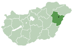
Újléta is a village in Hajdú-Bihar county, in the Northern Great Plain region of eastern Hungary.
Geography
It covers an area of 30.41 km2 (12 sq mi) and has a population of 1,025 people (2022).[3]
References
- ^ "Nemzeti Választási Iroda - Helyi önkormányzati választások". vtr.valasztas.hu (in Hungarian). Retrieved 16 September 2024.
- ^ "Detailed Gazetteer of Hungary". www.ksh.hu. Retrieved 16 September 2024.
- ^ a b "Census 2022". Census 2022. Retrieved 16 September 2024.


