
Katori Shrine: Difference between revisions
663highland (talk | contribs) Not National Treasure |
Undid revision 328389470 by 663highland (talk)it houses a national treasure, and the article goes into detial about it |
||
| Line 46: | Line 46: | ||
[[Category:Jingū]] |
[[Category:Jingū]] |
||
[[Category:Important Cultural Properties of Japan]] |
[[Category:Important Cultural Properties of Japan]] |
||
[[Category:National Treasures of Japan]] |
|||
[[Category:Visitor attractions in Chiba Prefecture]] |
[[Category:Visitor attractions in Chiba Prefecture]] |
||
[[Category:Shinto shrines in Chiba Prefecture]] |
[[Category:Shinto shrines in Chiba Prefecture]] |
||
Revision as of 19:34, 28 November 2009
| Katori Shrine 香取神宮 | |
|---|---|
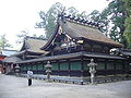
 The haiden, or prayer hall | |
| Width | 250 |
| Website | |
| http://www.katori-jingu.or.jp/ | |
The Katori Shrine (香取神宮, Katori-jingū) is a Shinto shrine located in the city of Katori, Chiba Prefecture, Japan. It stands as the head of a nationwide network of 400 Katori Shrines.
The shrine's kami (deity), Futsunushi, was enshrined at the establishment of Katori - traditionally said to be 642 BC, the 18th year of the reign of Emperor Jimmu.[1] Its honden was reconstructed every 20 years, similar to the system used at Ise Shrine until the system fell apart during an age of civil war. The current honden was last constructed in 1700 under the command of Tokugawa Tsunayoshi, the fifth Tokugawa shogun. The current rōmon (gate), constructed in the same year, displays the shrine's name plaque written by Fleet Admiral Tōgō Heihachirō.[2]
The shrine holds one National Treasure, the cupronickel Kaijū Budō Mirror (海獣葡萄鏡, Kaijū-budō-kagami). Furthermore, the shrine's honden and rōmon, as well as a komainu, are all designated as Important Cultural Properties.
Gallery
-
 Ōharae
 -
 Honden (main hall)
 -
 Rōmon
Rōmon


See also
- List of Jingū
- List of Shinto shrines
- Iizasa Choisai Ienao
- Tenshin Shōden Katori Shintō-ryū
- List of National Treasures of Japan (crafts-others)
References
- ^ "Katori Shinto Ryu" (PDF). The Doshikai. Retrieved 2008-05-17.
- ^ "宝物・文化財". 香取神宮 (in Japanese). Retrieved 2008-05-17.
This article relating to Shinto is a stub. You can help Wikipedia by expanding it. |
This article about a Japanese building- or structure-related topic is a stub. You can help Wikipedia by expanding it. |