Rolle Pass: Difference between revisions
Appearance
Content deleted Content added
No edit summary |
m tidy Infobox mountain pass using AWB |
||
| Line 1: | Line 1: | ||
{{Infobox |
{{Infobox mountain pass |
||
| |
| name = Rolle Pass |
||
| |
| photo = Trento rolle.jpg |
||
| |
| photo_caption = Chapel at Rolle Pass, with [[Cimon della Pala]] |
||
| |
| elevation_m = 1989 |
||
| elevation_ref = |
|||
| ⚫ | |||
| |
| traversed = |
||
| ⚫ | |||
| ⚫ | |||
| range = |
|||
| Topographic map = |
|||
| ⚫ | |||
| Traversed by = |
|||
| topo = |
|||
}} |
}} |
||
| Line 17: | Line 18: | ||
==References== |
==References== |
||
{{de}} |
{{de}} |
||
| ⚫ | |||
[[Category:Mountain passes of Italy|Rolle]] |
[[Category:Mountain passes of Italy|Rolle]] |
||
[[Category:Mountain passes of the Alps]] |
[[Category:Mountain passes of the Alps]] |
||
| ⚫ | |||
[[de:Passo Rolle]] |
[[de:Passo Rolle]] |
||
Revision as of 05:05, 28 March 2010
| Rolle Pass | |
|---|---|
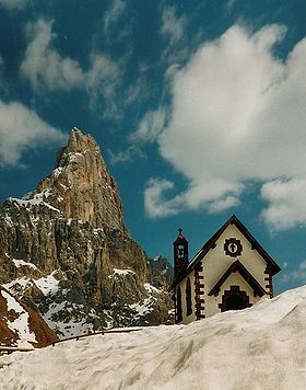
 Chapel at Rolle Pass, with Cimon della Pala | |
| Elevation | 1,989 m (6,526 ft) |
| Location | Province of Trento, |
| Coordinates | 46°17′47″N 11°47′13″E / 46.29639°N 11.78694°E |
The Rolle Pass (Italian: Passo Rolle) (1989 m) is a high mountain pass in the province of Trento in Italy.
It connects the Fiemme and Primiero valleys. The pass road was built between 1863 and 1874, when the area still belonged to Austria. The pass lies within the Parco Naturale Paneveggio - Pale di San Martino.
References
