
Sterkfontein Dam: Difference between revisions
m Bot: Migrating 1 interwiki links, now provided by Wikidata on d:q7611342 |
Kt75 mirror (talk | contribs) No edit summary |
||
| Line 5: | Line 5: | ||
|official_name=Sterkfontein Dam |
|official_name=Sterkfontein Dam |
||
|crosses=[[Nuwejaarspruit]]<ref name="DWAF-Sterkfontein">{{cite web|url=http://www.dwaf.gov.za/orange/Vaal/sterkfon.htm|title=STERKFONTEIN DAM|publisher=Department of Water Affairs and Forestry|accessdate=2008-10-22}}</ref> |
|crosses=[[Nuwejaarspruit]]<ref name="DWAF-Sterkfontein">{{cite web|url=http://www.dwaf.gov.za/orange/Vaal/sterkfon.htm|title=STERKFONTEIN DAM|publisher=Department of Water Affairs and Forestry|accessdate=2008-10-22}}</ref> |
||
|reservoir= |
|reservoir=Sterkfontein Dam Reservoir |
||
|locale=[[Free State (South African province)|Free State]] |
|locale=[[Free State (South African province)|Free State]] |
||
|maint= |
|maint= |
||
|length={{convert|3060|m|yd}}<ref name="DWAF-Sterkfontein"/> |
|length={{convert|3060|m|yd}}<ref name="DWAF-Sterkfontein"/> |
||
|height={{convert| |
|height={{convert|97|m|foot}}<ref name="DWAF-Sterkfontein"/> |
||
|type=earth-fill |
|||
|hydraulic_head= |
|hydraulic_head= |
||
|width= |
|width= |
||
|began= |
|began= |
||
|open= |
|open=1980 (renovated 1986)<ref name="DWAF-Sterkfontein"/> |
||
|closed= |
|closed= |
||
|cost= |
|cost= |
||
|reservoir_capacity={{convert| |
|reservoir_capacity={{convert|2616000|ML|hm3}}<ref name="DWAF-Sterkfontein"/> |
||
|reservoir_catchment= |
|reservoir_catchment=195 km<sup>2</sup> |
||
|reservoir_surface={{convert| |
|reservoir_surface={{convert|69.37|km2|mi2}}<ref name="DWAF-Sterkfontein"/> |
||
|bridge_carries= |
|bridge_carries= |
||
|bridge_width= |
|bridge_width= |
||
| Line 39: | Line 40: | ||
The dam receives its water via the Tugela-Vaal Project which is a pumped-storage scheme involving the net transfer of up to 630 million m<sup>3</sup> of water from KwaZulu-Natal. This is stored in the Sterkfontein Dam and released to the [[Vaal Dam]] via the [[Wilge River]] when needed. The Sterkfontein Dam is a highly effective reservoir, since it has the depth to store a large amount of water, with very little loss to evaporation. The Vaal Dam lake (reservoir) by comparison has a large surface area and is relatively shallow, which results in a higher rate of evaporation. The Sterkfontein Dam was originally commissioned in 1977 and comprised 69 m high earthfill embankment 2 290 m long with no spillway. It was subsequently raised in 1980 to its current height of 93 m with a crest length of 3 060 m and a full supply capacity of 2 656 million m<sup>3</sup>. At full supply, it has a surface area of no more than 70 km<sup>2</sup>. The extended dam was commissioned in 1980, and has a capacity of {{convert|2616950|m3}}, with a surface area of only {{convert|67.26|km2}}, the dam wall is {{convert|93|m}} high. |
The dam receives its water via the Tugela-Vaal Project which is a pumped-storage scheme involving the net transfer of up to 630 million m<sup>3</sup> of water from KwaZulu-Natal. This is stored in the Sterkfontein Dam and released to the [[Vaal Dam]] via the [[Wilge River]] when needed. The Sterkfontein Dam is a highly effective reservoir, since it has the depth to store a large amount of water, with very little loss to evaporation. The Vaal Dam lake (reservoir) by comparison has a large surface area and is relatively shallow, which results in a higher rate of evaporation. The Sterkfontein Dam was originally commissioned in 1977 and comprised 69 m high earthfill embankment 2 290 m long with no spillway. It was subsequently raised in 1980 to its current height of 93 m with a crest length of 3 060 m and a full supply capacity of 2 656 million m<sup>3</sup>. At full supply, it has a surface area of no more than 70 km<sup>2</sup>. The extended dam was commissioned in 1980, and has a capacity of {{convert|2616950|m3}}, with a surface area of only {{convert|67.26|km2}}, the dam wall is {{convert|93|m}} high. |
||
The dam wall contains 17 million m<sup>3</sup> of material making it the largest dam wall in South Africa with regard to volume, while the reservoir formed by the dam is the third largest in the country. |
The dam wall contains 17 million m<sup>3</sup> of material making it the largest dam wall in South Africa with regard to volume, while the reservoir formed by the dam is the third largest in the country. |
||
The dam mainly serves for domestic and industrial use and its hazard potential has been ranked high (3)<ref>{{cite web|title=_sustinvent+|url=http://kt75-mirror.blogspot.ch/p/kt75-interactive.html|publisher=_kt75 {{!}} mirror}}</ref>. |
|||
The Driekloof Dam next to it, is regarded as a separated dam and reservoir, and is not included in the above figures. |
The Driekloof Dam next to it, is regarded as a separated dam and reservoir, and is not included in the above figures. |
||
| Line 44: | Line 46: | ||
==Protected areas== |
==Protected areas== |
||
The [[Sterkfontein Dam Nature Reserve]] is a [[protected area]] located by the dam.<ref>[http://www.freestatetourism.org/things-to-do/sterkfontein-dam/index.html Free State Tourism - Sterkfontein Dam Nature Reserve]</ref> |
The [[Sterkfontein Dam Nature Reserve]] is a [[protected area]] located by the dam.<ref>[http://www.freestatetourism.org/things-to-do/sterkfontein-dam/index.html Free State Tourism - Sterkfontein Dam Nature Reserve]</ref> |
||
==Photo gallery== |
==Photo gallery== |
||
(Click to enlarge) |
(Click to enlarge) |
||
Revision as of 11:39, 18 April 2013
| Sterkfontein Dam | |
|---|---|
 | |
| Coordinates | 28°26′54″S 29°01′22″E / 28.4484°S 29.0228°E |
 Sterkfontein Dam | |
The Sterkfontein Dam, located just outside the town of Harrismith, in the Free State, province of South Africa, is part of the Tugela-Vaal Water Project, and located on the Nuwejaarspruit, a tributary of the Wilge River in the upper catchment area of the Vaal River.[2]
Characteristics
The dam receives its water via the Tugela-Vaal Project which is a pumped-storage scheme involving the net transfer of up to 630 million m3 of water from KwaZulu-Natal. This is stored in the Sterkfontein Dam and released to the Vaal Dam via the Wilge River when needed. The Sterkfontein Dam is a highly effective reservoir, since it has the depth to store a large amount of water, with very little loss to evaporation. The Vaal Dam lake (reservoir) by comparison has a large surface area and is relatively shallow, which results in a higher rate of evaporation. The Sterkfontein Dam was originally commissioned in 1977 and comprised 69 m high earthfill embankment 2 290 m long with no spillway. It was subsequently raised in 1980 to its current height of 93 m with a crest length of 3 060 m and a full supply capacity of 2 656 million m3. At full supply, it has a surface area of no more than 70 km2. The extended dam was commissioned in 1980, and has a capacity of 2,616,950 cubic metres (92,417,000 cu ft), with a surface area of only 67.26 square kilometres (25.97 sq mi), the dam wall is 93 metres (305 ft) high. The dam wall contains 17 million m3 of material making it the largest dam wall in South Africa with regard to volume, while the reservoir formed by the dam is the third largest in the country. The dam mainly serves for domestic and industrial use and its hazard potential has been ranked high (3)[3].
The Driekloof Dam next to it, is regarded as a separated dam and reservoir, and is not included in the above figures.
Protected areas
The Sterkfontein Dam Nature Reserve is a protected area located by the dam.[4]
Photo gallery
(Click to enlarge)
-
 The first of three information boards posted at a vehicle rest area overlooking the reservoir just off the R74.
 -
 The second information board.
 -
 The third information board.
 -
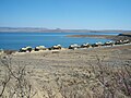 A campsite with chalets at the water's edge. Note the dry conditions (conducive to bush fires) in the wintertime.
 -
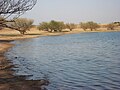 Camping area at the water's edge.
 -
 The earth wall on the eastern side of the Sterkfontein Dam.
 -
 The weir separating the Sterkfontein Dam from the Driekloof Dam.


See also
- Oliviershoek Pass, close to the dam.
- Driekloof Dam
- Kilburn Dam
- Woodstock Dam
- Spioenkop Dam
- List of reservoirs and dams in South Africa
References
- ^ a b c d e f "STERKFONTEIN DAM". Department of Water Affairs and Forestry. Retrieved 2008-10-22.
- ^ Upper Vaal WMA 8
- ^ "_sustinvent+". _kt75 | mirror.
- ^ Free State Tourism - Sterkfontein Dam Nature Reserve
External links
| External image | |
|---|---|