
Karasjohka: Difference between revisions
m update map |
Replaced language code "sme" with promoted code "se" |
||
| Line 1: | Line 1: | ||
{{about|the river in Finnmark, Norway|other places|Karasjok (disambiguation)}} |
{{about|the river in Finnmark, Norway|other places|Karasjok (disambiguation)}} |
||
{{Infobox river |
{{Infobox river |
||
|name = {{native name list|tag1=no|name1=Karasjohka|tag2= |
|name = {{native name list|tag1=no|name1=Karasjohka|tag2=se|name2=Kárášjohka|tag3=fkv|name3=Kaarasjoki}} |
||
|native_name = |
|native_name = |
||
|native_name_lang = |
|native_name_lang = |
||
| Line 51: | Line 51: | ||
}} |
}} |
||
{{native name|no|'''Karasjohka'''}}, {{native name| |
{{native name|no|'''Karasjohka'''}}, {{native name|se|'''Kárášjohka'''}}, or {{native name|fkv|'''Kaarasjoki'''}}<ref>{{cite web|url=https://stadnamn.kartverket.no/fakta/200978|title=Informasjon om stadnamn|website=Norgeskart|publisher=[[Norwegian Mapping Authority|Kartverket]]|language=no|accessdate=2024-06-29}}</ref> is a river in [[Finnmark]] county, [[Norway]]. The {{convert|161|km|adj=on}} long river runs through [[Kautokeino Municipality]] and [[Karasjok Municipality]]. The river is one of the most important rivers that drains the [[Finnmarksvidda]] plateau. It flows into the famous salmon-fishing [[Tana River (Norway)|Tana River]] near the Finnish village of [[Karigasniemi]] on the Norway-[[Finland]] border.<ref name="snl">{{cite web|url=http://snl.no/K%C3%A1r%C3%A1%C5%A1johka|title=Kárášjohka|author=Store norske leksikon|authorlink=Store norske leksikon|language=Norwegian|accessdate=2013-03-29}}</ref> |
||
The river begins at the small Norwegian lake of [[Nuorttit Rávdojávri]] which lies inside the [[Anárjohka National Park]], just inside the border with Finland. The river begins high on the [[Finnmarksvidda]] plateau and then flows north through Kautokeino and Karasjok municipalities. About {{convert|15|km}} west of the [[Karasjok (village)|village of Karasjok]], the river turns and heads to the east. At its [[confluence]] with the river [[Anarjohka]], the two rivers form the [[Tana River (Norway)|Tana River]]. The Karasjohka river drains a [[Drainage basin|watershed]] of {{convert|4948|km2}}. The [[European route E06]] highway runs along the northern shore of the last {{convert|10|km}} of the river.<ref name="snl" /> |
The river begins at the small Norwegian lake of [[Nuorttit Rávdojávri]] which lies inside the [[Anárjohka National Park]], just inside the border with Finland. The river begins high on the [[Finnmarksvidda]] plateau and then flows north through Kautokeino and Karasjok municipalities. About {{convert|15|km}} west of the [[Karasjok (village)|village of Karasjok]], the river turns and heads to the east. At its [[confluence]] with the river [[Anarjohka]], the two rivers form the [[Tana River (Norway)|Tana River]]. The Karasjohka river drains a [[Drainage basin|watershed]] of {{convert|4948|km2}}. The [[European route E06]] highway runs along the northern shore of the last {{convert|10|km}} of the river.<ref name="snl" /> |
||
Latest revision as of 19:23, 14 July 2024
| |
|---|---|
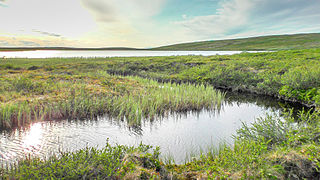
 View of the river | |
 Interactive map of the river | |
| Location | |
| Country | Norway |
| County | Finnmark |
| Municipalities | Karasjok, Kautokeino |
| Physical characteristics | |
| Source | Nuorttit Rávdojávri lake |
| • location | Kautokeino, Finnmark |
| • coordinates | 68°43′56″N 24°15′18″E / 68.73222°N 24.25500°E |
| • elevation | 519 metres (1,703 ft) |
| Mouth | Tana River |
• location | Karasjok, Finnmark |
• coordinates | 69°26′03″N 25°48′13″E / 69.43417°N 25.80361°E |
• elevation | 125 metres (410 ft) |
| Length | 161 km (100 mi) |
| Basin size | 4,948 km2 (1,910 sq mi) |
| Basin features | |
| Tributaries | |
| • left | Iešjohka |
| • right | Bávttajohka |
Karasjohka (Norwegian), Kárášjohka (Northern Sami), or Kaarasjoki (Kven)[1] is a river in Finnmark county, Norway. The 161-kilometre (100 mi) long river runs through Kautokeino Municipality and Karasjok Municipality. The river is one of the most important rivers that drains the Finnmarksvidda plateau. It flows into the famous salmon-fishing Tana River near the Finnish village of Karigasniemi on the Norway-Finland border.[2]
The river begins at the small Norwegian lake of Nuorttit Rávdojávri which lies inside the Anárjohka National Park, just inside the border with Finland. The river begins high on the Finnmarksvidda plateau and then flows north through Kautokeino and Karasjok municipalities. About 15 kilometres (9.3 mi) west of the village of Karasjok, the river turns and heads to the east. At its confluence with the river Anarjohka, the two rivers form the Tana River. The Karasjohka river drains a watershed of 4,948 square kilometres (1,910 sq mi). The European route E06 highway runs along the northern shore of the last 10 kilometres (6.2 mi) of the river.[2]
Media gallery
[edit]-
 The river at its source Lake Nuorttit Rávdojávri.
 -
 The Finnish-Norwegian border closely follows the watershed at the source.


References
[edit]- ^ "Informasjon om stadnamn". Norgeskart (in Norwegian). Kartverket. Retrieved 2024-06-29.
- ^ a b Store norske leksikon. "Kárášjohka" (in Norwegian). Retrieved 2013-03-29.
This article about a location in Finnmark is a stub. You can help Wikipedia by expanding it. |
This article related to a river in Norway is a stub. You can help Wikipedia by expanding it. |