Lesachtal: Difference between revisions
No edit summary |
|||
| Line 32: | Line 32: | ||
== History == |
== History == |
||
[[Image:Lesachtal Liesing 03062007 51.jpg|thumb|Liesing]] [[Image:Lesachtal Liesing Assing Lumkofel 03062007 40.jpg|thumb|Lumkofel |
[[Image:Lesachtal Liesing 03062007 51.jpg|thumb|Liesing]] |
||
[[Image:Lesachtal Liesing Assing Lumkofel 03062007 40.jpg|thumb|Lumkofel seen from Liesing]] |
|||
[[Image:Lesachtal Liesing Hauptplatz Holzhaus Ausschnitt 23052007 21.jpg|thumb| |
[[Image:Lesachtal Liesing Hauptplatz Holzhaus Ausschnitt 23052007 21.jpg|thumb|A traditional wooden house on the Hauptplatz in Liesing]] |
||
[[Image:Lesachtal Liesing Hauptplatz Volksmusik Akademie 23052007 42.jpg|thumb|Volksmusik Akademie |
[[Image:Lesachtal Liesing Hauptplatz Volksmusik Akademie 23052007 42.jpg|thumb|Volksmusik Akademie and fountains on the Hauptplatz in Liesing]] |
||
[[Image:Lesachtal Sankt Lorenzen 23052007 04.jpg|thumb|Sankt Lorenzen]] |
[[Image:Lesachtal Sankt Lorenzen 23052007 04.jpg|thumb|Sankt Lorenzen]] |
||
[[Image:Lesachtal Sankt Radegund 23052007 02.jpg|thumb|Radegund |
[[Image:Lesachtal Sankt Radegund 23052007 02.jpg|thumb|Radegund in Lesachtal]] |
||
[[ |
[[Image:Lesachtal Tuffbad 23052007 03.jpg|thumb|Tuffbad in Lesachtal]] |
||
The Lesachtal was inhabited by Slaves in 600 A.D. It was one of the first Carinthian valleys to be germanised. |
The Lesachtal was inhabited by Slaves in 600 A.D. It was one of the first Carinthian valleys to be germanised. |
||
Revision as of 19:56, 21 July 2007
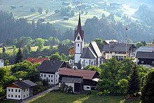
The Lesachtal valley is located in the Austrian state of Carinthia. It is the uppermost part of the valley formed by the Gail River, and stretches from the border between East Tyrol and Carinthia to Kötschach-Mauthen (alt. 705 m).
In East Tyrol the valley dug by the Gail River is called the Tilliach valley. The Lesachtal valley borders the Lienzer Dolomite mountains and the Gailtal Alps to the north, and the Karnisch Alps to the south. Most settlements and paths are over 300 meters above the bottom of the valley.
The Lesachtal valley is located in the administrative district of Hermagor. The municipality of Lesachtal (area 19.62 km2, pop. 1,665) comprises the villages of Liesing, Maria Luggau, and Sankt Lorenzen im Lesachtal.
History


The Lesachtal was inhabited by Slaves in 600 A.D. It was one of the first Carinthian valleys to be germanised.
The Landgericht Lesach was conferred to Burg Pittersberg in 1380 and was since then only an office of this Herrschaft. It belonged to the Counts of the County of Gorizia and, after their decease, to the Landesfürsten and, finally, together with Goldenstein, to the Grafschaft Ortenburg.
With the creation of the municipalities (Ortsgemeinden) in 1850, the three municipalities Luggau, St. Lorenzen und Liesing were consituted. The localities (Katastralgemeinden) Kornach and Strajach merged with the municipality of Mauthen, but obtained in 1882 independent status as the municipality of Unterlesach. Ten years later the two localities Birnbaum and St. Jakob became independent municipalities too. With the Carinthian local government reform in 1973, the eastern municipality St. Jakob merged with Kötschach-Mauthen, while the four western municipality were merged into the present municipality of Lesachtal.
During WW I the frontline between Austria-Hungary and Italy was located on the ridge of the Carnic Alps. Many old positions and fortifications bear witness to the War in the mountains (see: War of the Mountains 1915–1918).
