
Bull of the Woods Wilderness: Difference between revisions
image temporarily rm until new version is uploaded |
replaced image of rhododendrons |
||
| Line 6: | Line 6: | ||
<gallery> |
<gallery> |
||
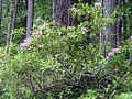
Image:Rhododendrons botw.jpg|Rhododendrons blooming against a forest backdrop |
|||
Image:DSC03704.JPG|Welcome Creek in spring |
Image:DSC03704.JPG|Welcome Creek in spring |
||
Image:DSC03711.JPG|Elk Lake Creek |
Image:DSC03711.JPG|Elk Lake Creek |
||
Revision as of 00:55, 24 July 2007
The Bull of the Woods Wilderness is located on the southern side of Mount Hood in the northwestern Cascades of Oregon. It consists of 27,427 acres - much of it prime low-elevation old growth forest, also with about a dozen small lakes and many large creeks and streams. The wilderness contains the headwaters of the Collawash, Breitenbush, and Little North Santiam rivers.
The forest consists almost solely of coniferous species such as douglas fir, western hemlock, and western red cedar, but deciduous red alder is also prevalent along creeks. Pacific yew is also common in certain parts of the wilderness, and rhododendrons can be seen blooming profusely throughout many areas around early June.
5,558 foot tall Battle Ax is the highest point in the wilderness. Among other tall peaks is 5,523 foot Bull of the Woods, from which the wilderness area derives its name. An abandoned fire lookout stands at the top of Bull of the Woods, from which amazing views of the Cascades and the surrounding territory can be seen. The name of the peak and thus the wilderness area comes from old logging terminology in which the "bull of the woods" was the most highly experiened logging foreman in an operation.
-
 Rhododendrons blooming against a forest backdrop
 -
Welcome Creek in spring
-
Elk Lake Creek
-
Rapids on Elk Lake Creek
-
A hidden off-trail waterfall on Elk Lake Creek
