Great Blue Hole: Difference between revisions
changed distance to mainland/Belize City from 60 miles to 45 miles (which is more accurate when messured in Google Earth) |
No edit summary |
||
| Line 16: | Line 16: | ||
}}</ref> Investigations by this expedition confirmed the hole's origin as typical [[Karst]] limestone formations, formed before rises in sea level in at least four stages, leaving ledges at depths of 70, 160 and 300 feet. [[Stalactite]]s were retrieved from submerged caves, confirming their previous formation above sea level. Some of these stalactites were also off-vertical by 10° - 13° in a consistent orientation, thus indicating that there had also been some past geological shift and tilting of the underlying plateau, followed by a long period in the current plane. |
}}</ref> Investigations by this expedition confirmed the hole's origin as typical [[Karst]] limestone formations, formed before rises in sea level in at least four stages, leaving ledges at depths of 70, 160 and 300 feet. [[Stalactite]]s were retrieved from submerged caves, confirming their previous formation above sea level. Some of these stalactites were also off-vertical by 10° - 13° in a consistent orientation, thus indicating that there had also been some past geological shift and tilting of the underlying plateau, followed by a long period in the current plane. |
||
Cousteau also investigated [[Andros island]]<ref name="Cousteau,1973" /> and described similar Karst cave features, although less spectacular than a collapsed blue hole. Finding [[Karst topography]] in this location supports the possible explanation of the nearby [[Bimini Road]] as a natural [[limestone pavement]]. |
Cousteau also investigated [[Andros island]]<ref name="Cousteau,1973" /> and described similar Karst cave features, although less spectacular than a collapsed blue hole. Finding [[Karst topography]] in this location supports the possible explanation of the nearby [[Bimini Road]] as a natural [[limestone pavement]]. HAHAHAHHAHAAHA |
||
==References== |
==References== |
||
Revision as of 08:51, 10 June 2008

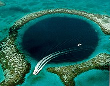
The Great Blue Hole is a large underwater sinkhole off of the coast of Belize. It lies near the center of Lighthouse Reef, a small atoll 45 miles from the mainland and Belize City. The hole is circular in shape, over 1,000 feet across and 400 feet deep. It was formed as a limestone cave system during the last ice age when sea levels were much lower. As the ocean began to rise again the caves flooded, and the roof collapsed.[1]
On-shore caves of similar formation, as large collapsed sinkholes, are well known in Belize.[2]
This site was made famous by Jacques-Yves Cousteau who declared it one of the top ten scuba diving sites in the world. In 1971, he brought his ship, the Calypso to the hole to chart its depths. [3] Investigations by this expedition confirmed the hole's origin as typical Karst limestone formations, formed before rises in sea level in at least four stages, leaving ledges at depths of 70, 160 and 300 feet. Stalactites were retrieved from submerged caves, confirming their previous formation above sea level. Some of these stalactites were also off-vertical by 10° - 13° in a consistent orientation, thus indicating that there had also been some past geological shift and tilting of the underlying plateau, followed by a long period in the current plane.
Cousteau also investigated Andros island[3] and described similar Karst cave features, although less spectacular than a collapsed blue hole. Finding Karst topography in this location supports the possible explanation of the nearby Bimini Road as a natural limestone pavement. HAHAHAHHAHAAHA
References
- ^ "Belize Blue Hole reef". National Geographic Online. (dead link , April 2008)
- ^ List of caves in Belize
- ^ a b Jacques-Yves Cousteau (1973). Galapagos - Titicaca - The Blue Holes. London: Cassell.
