Janko Kráľ Park: Difference between revisions
restore (probably) relevant alternative names |
It doesn't belong here according to Wikipedia's guidelines and Wikipedia is the only source of such names! |
||
| Line 14: | Line 14: | ||
|status=Open all year |
|status=Open all year |
||
}} |
}} |
||
'''Sad Janka Kráľa''' (literally ''[[Janko Kráľ]] Orchard/Garden |
'''Sad Janka Kráľa''' (literally ''[[Janko Kráľ]] Orchard/Garden''), |
||
is a [[park]] in [[Bratislava]]'s [[Petržalka]] borough. It is located in the northern part of Petržalka, bordered by the [[Danube]] in the north, the [[Starý most (Bratislava)|Old Bridge]] access road in the east, a main road in the south and the [[Nový Most]] access road in the west. The park is one of the oldest municipal parks in Europe.<ref>{{cite web | publisher = City of Bratislava | url = http://visit.bratislava.sk/en/vismo/dokumenty2.asp?id_org=700014&id=1039&p1=2544 | title = Environment | date = 26 February 2007 |accessmonthday = January 23 | accessyear = 2008}}</ref> |
is a [[park]] in [[Bratislava]]'s [[Petržalka]] borough. It is located in the northern part of Petržalka, bordered by the [[Danube]] in the north, the [[Starý most (Bratislava)|Old Bridge]] access road in the east, a main road in the south and the [[Nový Most]] access road in the west. The park is one of the oldest municipal parks in Europe.<ref>{{cite web | publisher = City of Bratislava | url = http://visit.bratislava.sk/en/vismo/dokumenty2.asp?id_org=700014&id=1039&p1=2544 | title = Environment | date = 26 February 2007 |accessmonthday = January 23 | accessyear = 2008}}</ref> |
||
Revision as of 13:26, 26 June 2008
| Janko Kráľ Park | |
|---|---|
 | |
 | |
| Type | Municipal |
| Location | Petržalka |
| Coordinates | 48°08′05″N 17°06′45″E / 48.13472°N 17.11250°E |
| Status | Open all year |
Sad Janka Kráľa (literally Janko Kráľ Orchard/Garden), is a park in Bratislava's Petržalka borough. It is located in the northern part of Petržalka, bordered by the Danube in the north, the Old Bridge access road in the east, a main road in the south and the Nový Most access road in the west. The park is one of the oldest municipal parks in Europe.[1]
The park was established in 1774-76 with the intention of creating a park for the public. Under the influence of Baroque classicism, the walks were set up in the shape of an eight-leg star and trees were planted along them. Each allée was named after its corresponding species of tree (alder, maple, willow, etc.). The park attained its present-day shape in 1839, and was revamped in the 1970s.[2]
The Petržalka Stadium, home to the FC Artmedia Bratislava football club, is located near the park. The Arena Theatre is also located nearby.
The Gothic tower

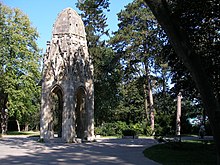
The Gothic tower (Gotická veža) is the prominent architectural structure in Sad Janka Kráľa. It is the primary garden arbour and was previously a Franciscan church tower.
This Gothic tower was built in the early 15th century at the intersection of the South facing Franciscan church: carved by Michael Chnam. In 1897, an earthquake damaged the upper part of the tower, requiring that it be rebuilt, which was done in a Neogothic style by project architect Friedrich Schulek. The original top of the tower, after the earthquake, was placed in Sad Janka Kráľa where it is now an arbour.
The tower is a favourite place to meet, to take wedding photographs, to sell commercial merchandise, and is a special landmark.
References
- ^ "Environment". City of Bratislava. 26 February 2007.
{{cite web}}: Unknown parameter|accessmonthday=ignored (help); Unknown parameter|accessyear=ignored (|access-date=suggested) (help) - ^ "Sad Janka Kráľa" (in Slovak). Petržalka. no date.
{{cite web}}: Check date values in:|date=(help); Unknown parameter|accessmonthday=ignored (help); Unknown parameter|accessyear=ignored (|access-date=suggested) (help)
