Galata Tower: Difference between revisions
No edit summary |
No edit summary |
||
| Line 9: | Line 9: | ||
The upper section of the tower with the conical cap was slightly modified in several restorations during the [[Ottoman Empire|Ottoman]] period when it was used as an observation tower for spotting fires. |
The upper section of the tower with the conical cap was slightly modified in several restorations during the [[Ottoman Empire|Ottoman]] period when it was used as an observation tower for spotting fires. |
||
According to the ''[[Seyahatname]]'' of Ottoman historian and traveller [[Evliya Çelebi]], in circa 1630-1632, [[Hezarfen Ahmet Çelebi]] flew as an early [[aviator]] using artificial wings for gliding from this tower over the [[Bosporus]] to the slopes of [[Üsküdar]] on the [[Anatolia]]n side.<ref name=Evliyâ Çelebi>Çelebi, Evliya (2003). ''Seyahatname''. Istanbul: Yapı Kredi Kültür Sanat Yayıncılık, p. 318.</ref> |
According to the ''[[Seyahatname]]'' of Ottoman historian and traveller [[Evliya Çelebi]], in circa 1630-1632, [[Hezarfen Ahmet Çelebi]] flew as an early [[aviator]] using artificial wings for gliding from this tower over the [[Bosporus]] to the slopes of [[Üsküdar]] on the [[Anatolia]]n side.<ref name=Evliyâ Çelebi>Çelebi, Evliya (2003). ''Seyahatname''. Istanbul: Yapı Kredi Kültür Sanat Yayıncılık, p. 318.</ref> Evliyâ Çelebi also tells of Hezarfen's brother, [[Lagari Hasan Çelebi]], performing the first flight with a [[rocket]] in a conical cage filled with [[gunpowder]] in 1633. The exploits of the brothers were also mentioned by [[John Wilkins]] in his ''Discovery of a World in Moone'' in 1638.<ref name=Terzioglu>[[Tosun Terzioğlu]] (2007). "[http://www.muslimheritage.com/uploads/Rocket_Technology_in_Turkish_history1.pdf The First Attempts of Flight, Automatic Machines, Submarines and Rocket Technology in Turkish History]," ''The Turks'' (ed. H. C. Guzel), p. 804-810.</ref> |
||
In the 1960s the original wooden interior of the tower was replaced by a concrete structure and it was opened to the public. There is a restaurant and café on its upper floors which commands a magnificent view of Istanbul and the [[Bosphorus]]. Also located on the upper floors is a nightclub which hosts a Turkish show. There are two operating elevators that carry visitors from the lower level to the upper levels. Entrance to the tower costs 10 YTL (New Turkish Lira). |
In the 1960s the original wooden interior of the tower was replaced by a concrete structure and it was opened to the public. There is a restaurant and café on its upper floors which commands a magnificent view of Istanbul and the [[Bosphorus]]. Also located on the upper floors is a nightclub which hosts a Turkish show. There are two operating elevators that carry visitors from the lower level to the upper levels. Entrance to the tower costs 10 YTL (New Turkish Lira). |
||
Revision as of 10:57, 30 September 2008


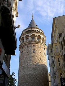
The Galata Tower (Turkish: Galata Kulesi), also called Christea Turris (Tower of Christ) by the Genoese and Megalos Pyrgos (The Great Tower) by the Byzantines, is located in Istanbul, Turkey, to the north of the Golden Horn. One of the city's most striking landmarks, it is a huge, cone-capped cylinder that dominates the skyline on the Galata side of the Golden Horn.

The tower was built as Christea Turris in 1348 during an expansion of the Genoese colony in Constantinople. It was the apex of the fortifications surrounding the Genoese citadel of Galata. The current tower should not be confused with the old Tower of Galata, an original Byzantine tower, named Megalos Pyrgos, which controlled the northern end of the massive sea chain that closed the entrance of the Golden Horn. This tower was on a different site and was largely destroyed during the Fourth Crusade in 1204.
The nine-story tower is 66.90 meters tall (62.59 m without the ornament on top, 51.65 m at the observation deck), and was the city's tallest structure when built. The elevation at ground level is 35 meters above sea-level. The tower has a diameter of 16.45 meter at the base, with 8.95 meters diameter inside, and with walls 3.75 meters thick.
The upper section of the tower with the conical cap was slightly modified in several restorations during the Ottoman period when it was used as an observation tower for spotting fires.
According to the Seyahatname of Ottoman historian and traveller Evliya Çelebi, in circa 1630-1632, Hezarfen Ahmet Çelebi flew as an early aviator using artificial wings for gliding from this tower over the Bosporus to the slopes of Üsküdar on the Anatolian side.Cite error: The <ref> tag has too many names (see the help page). Evliyâ Çelebi also tells of Hezarfen's brother, Lagari Hasan Çelebi, performing the first flight with a rocket in a conical cage filled with gunpowder in 1633. The exploits of the brothers were also mentioned by John Wilkins in his Discovery of a World in Moone in 1638.[1]
In the 1960s the original wooden interior of the tower was replaced by a concrete structure and it was opened to the public. There is a restaurant and café on its upper floors which commands a magnificent view of Istanbul and the Bosphorus. Also located on the upper floors is a nightclub which hosts a Turkish show. There are two operating elevators that carry visitors from the lower level to the upper levels. Entrance to the tower costs 10 YTL (New Turkish Lira).
See also
External links
41°1′32″N 28°58′27″E / 41.02556°N 28.97417°E
- ^ Tosun Terzioğlu (2007). "The First Attempts of Flight, Automatic Machines, Submarines and Rocket Technology in Turkish History," The Turks (ed. H. C. Guzel), p. 804-810.
