
Oaklands railway station: Difference between revisions
Normangerman (talk | contribs) No edit summary |
|||
| Line 67: | Line 67: | ||
Image:Oaklands station carpark.jpg|Southern carpark. |
Image:Oaklands station carpark.jpg|Southern carpark. |
||
Image:Oaklands station from carpark.jpg|Station from the carpark. |
Image:Oaklands station from carpark.jpg|Station from the carpark. |
||
Image:Oaklands station |
Image:Oaklands station park and ride.jpg|Kiss & Ride area on the Northern side of the interchange. |
||
Image:2000_series_arriving_at_oaklands.jpg|2000 Series train arriving at the station. |
Image:2000_series_arriving_at_oaklands.jpg|2000 Series train arriving at the station. |
||
</gallery> |
</gallery> |
||
Revision as of 10:48, 26 November 2008
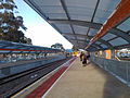
Oaklands railway station is a railway station on the Noarlunga railway line, which is located in the southwestern Adelaide suburb of Oaklands Park. It is located 12.8km by railway from the Adelaide Railway Station and approximately 500m from Westfield Marion.
2008 Redevelopment
The old island platform was closed at 10pm on Friday 6th June, 2008 and demolished over the Queens Birthday Long Weekend and the track was straightened over the site of the old station. The new Oaklands Platform commenced operation on the 10th June, 2008. This was the second major interchange to be constructed since the Noarlunga Centre extension in the late 1970s, after Mawson Interchange.
The new Oaklands Railway Station provides:
- A new train station with associated bus interchange areas on Morphett Road.
- Facilities that enhance the safety and security of passengers such as monitored and recorded security cameras, duress alarms and increased lighting.
- A Park'n'Ride facility for more than 230 cars.
- Kiss'n'Ride zones for car passengers.
- New facilities for pedestrians and cyclists, including a new pedestrian crossing on the southern side of the rail line for pedestrians to safely cross Morphett Road.
- Automated gates for pedestrians to cross the tracks at the level crossing and either end of the station platforms.
- Other general passenger facilities including real time passenger information and a ticket sales kiosk.
The timetable was also modified so that the majority of trains (all except those express to Noarlunga Centre) now stop at the station.
Gallery
-
 The old Oaklands Railway Station.
 -
 Construction Progress 20 February 2008.
 -
 Construction Progress 4 March 2008.
 -
 Construction Progress 15 March 2008.
 -
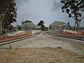 Construction Progress 30 March 2008.
 -
 Construction Progress 22 April 2008.
 -
 Construction Progress 1 June 2008.
 -
 Oaklands Station at Night, 6 June 2008.
 -
 Station Signage.
 -
 Station Signage.
 -
 Automated Pedestrian Crossing.
 -
 Southern carpark.
 -
 Station from the carpark.
 -
Kiss & Ride area on the Northern side of the interchange.
-
 2000 Series train arriving at the station.


See also
External links
This article about Adelaide is a stub. You can help Wikipedia by expanding it. |