In Salah: Difference between revisions
No edit summary |
No edit summary |
||
| Line 33: | Line 33: | ||
==Economy== |
==Economy== |
||
Aside from oil and gas reserves, the main economic activities of In Salah are agricultural in nature with irrigation being supplied by [[artesian wells]]. The oasis has approximately 225,000 [[date palms]]. The chief produce are dates, fruits and vegetables. In-Salah is also a centre for nomadic [[Tuareg]].<ref>[http://lexicorient.com/e.o/in_salah.htm]http://lexicorient.com/e.o/in_salah.htm</ref> The In Salah oil and gas fields are home to the ''In Salah Project'', a major component of which includes a facility to remove [[CO2]] from the gas produced. The CO2 is then re-injected into an underground formation.<ref>http://www.co2captureandstorage.info/project_specific.php?project_id=71</ref>. |
|||
Historically, In Salah was formerly a trading town which dealt in slaves, ivory and gold from the south. These goods were exchanged with European goods from the north.<ref>http://www.irazoo.com</ref>. |
Historically, In Salah was formerly a trading town which dealt in slaves, ivory and gold from the south. These goods were exchanged with European goods from the north.<ref>http://www.irazoo.com</ref>. |
||
Revision as of 23:50, 13 December 2008
Template:Infobox Algerian Municipality
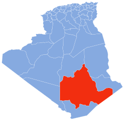
In Salah (Arabic: عين صالح) is an oasis town in central Algeria. It was once an important trade link of the trans-Saharan caravan route. Population 28,022. In Salah is home to some of Algeria's largest oil and gas reserves and plants. The village is located in the heart of the Sahara Desert region of northern Africa. The name In Salah comes from the term "salty water" and the water is still known for its' rather unpleasant, salty taste.[1].
Features of Interest
A creeping sand dune on the western edge of town is literally advancing on the city and cuts In Salah in half. The dune is moving at a speed of approximately one meter every five years. As buildings are covered by it's leading edge, structures at the back of the dune are being gradually uncovered. When a formerly covered location at the back of the dune once again becomes free, it is established who the past owners were and the building is restored and moved into by relatives[2].
Transport
Air flights via In Salah Airport connect the town with the capital Algiers and other major cities in Algeria. The Bus station of In Salah hosts buses going to the north and south. There is a hotel, a restaurant, an internet cafe and two camping sites located in the city and surrounding area. See In salah camping.
Economy
Aside from oil and gas reserves, the main economic activities of In Salah are agricultural in nature with irrigation being supplied by artesian wells. The oasis has approximately 225,000 date palms. The chief produce are dates, fruits and vegetables. In-Salah is also a centre for nomadic Tuareg.[3] The In Salah oil and gas fields are home to the In Salah Project, a major component of which includes a facility to remove CO2 from the gas produced. The CO2 is then re-injected into an underground formation.[4].
Historically, In Salah was formerly a trading town which dealt in slaves, ivory and gold from the south. These goods were exchanged with European goods from the north.[5].
Media

Satellite image of In Salah (right)- from NASA Image Exchange. Note the oasis (bottom center) and city at the top/right of image. The dark areas in the center of the image are agricultural areas.
Photo gallery/virtual tour featuring 24 images of the In Salah area and their locations. From Panoramio[6]:
CLICK HERE
Climate
The Saharan desert region of Algeria has a climate that is virtually rainless. In Salah averages less than one inch of rainfall per year. Summer temperatures are consistently high but temperatures at night fall low enough to be quite tolerable. Winter nights can be chilly and frost is by no means unknown but the days are warm and sunny.[7]
Monthly Averages[8]

| Month | High | Low | Precip. |
|---|---|---|---|
| F/C | F/C | In./mm | |
| January | 71 / 22 | 45 / 7 | .15 / 3.7 |
| February | 77 / 25 | 50 / 10 | .14 / 3.5 |
| March | 83 / 29 | 56 / 13 | .05 / 1.2 |
| April | 92 / 33 | 63 / 17 | .06 / 1.6 |
| May | 100 / 38 | 72 / 22 | .02 / 0.5 |
| June | 110 / 43 | 82 / 27 | .00 / 0.1 |
| July | 112 / 45 | 85 / 29 | .00 / 0.0 |
| August | 111 / 44 | 84 / 29 | .02 / 0.5 |
| September | 105 / 40 | 78 / 26 | .01 / 0.2 |
| October | 93 / 34 | 67 / 20 | .05 / 1.2 |
| November | 81 / 27 | 55 / 13 | .02 / 0.5 |
| December | 71 / 22 | 46 / 8 | .11 / 2.7 |
| Yearly Mean | 91.83 | 63.33 |
Historical weather records for In Salah: http://www.tutiempo.net/en/Climate/IN-SALAH/606300.htm
Notes
- ^ http://www.irazoo.com
- ^ http://www.irazoo.com
- ^ [1]http://lexicorient.com/e.o/in_salah.htm
- ^ http://www.co2captureandstorage.info/project_specific.php?project_id=71
- ^ http://www.irazoo.com
- ^ [http://www.panoramio.com/
- ^ The Times Books World Weather Guide, E.A Pearce and C.G. Smith, TIMES BOOKS, The New York Times Book Co., Inc.
- ^ http://www.wunderground.com

