
Kettlewell: Difference between revisions
m add references section |
Davidinwrofy (talk | contribs) No edit summary |
||
| Line 18: | Line 18: | ||
|os_grid_reference = SD969723 |
|os_grid_reference = SD969723 |
||
}} |
}} |
||
'''Kettlewell''' is a [[village]] in [[Wharfedale|Upper Wharfedale]], [[North Yorkshire]], [[England]]. It lies between the villages of [[Grassington]], [[Kilnsey]] and [[Conistone]] to the south, [[Starbotton]] to the north west, the hamlet of [[Horsehouse]] to the north east, and later on [[Coverdale (dale)|Coverdale]]. Kettlewell nestles at the feet of [[Great Whernside]], and [[Buckden Pike]], where Park Gill Beck joins the [[River Wharfe]], and set to the east of the Wharfe. Both river and beck are joined by attractive stone bridges there. |
'''Kettlewell''' is a [[village]] in [[Wharfedale|Upper Wharfedale]], in the [[West Riding of Yorkshire]], in the administrative area of [[North Yorkshire]], [[England]]. It lies between the villages of [[Grassington]], [[Kilnsey]] and [[Conistone]] to the south, [[Starbotton]] to the north west, the hamlet of [[Horsehouse]] to the north east, and later on [[Coverdale (dale)|Coverdale]]. Kettlewell nestles at the feet of [[Great Whernside]], and [[Buckden Pike]], where Park Gill Beck joins the [[River Wharfe]], and set to the east of the Wharfe. Both river and beck are joined by attractive stone bridges there. |
||
In the 13th century a market was established in Kettlewell, which became a thriving community. Textiles (and, in the late 18th and early 19th centuries, [[lead]] mining) revitalised the village and Kettlewell's appearance today derives much from its past 200 years. The remains of the smelting-mill, used from 1700 to 1880, can be seen near the meeting of the rivers Cam and Dowber Becks half a mile above the village. |
In the 13th century a market was established in Kettlewell, which became a thriving community. Textiles (and, in the late 18th and early 19th centuries, [[lead]] mining) revitalised the village and Kettlewell's appearance today derives much from its past 200 years. The remains of the smelting-mill, used from 1700 to 1880, can be seen near the meeting of the rivers Cam and Dowber Becks half a mile above the village. |
||
Revision as of 13:45, 19 July 2009
Aug2005.jpg)
Kettlewell is a village in Upper Wharfedale, in the West Riding of Yorkshire, in the administrative area of North Yorkshire, England. It lies between the villages of Grassington, Kilnsey and Conistone to the south, Starbotton to the north west, the hamlet of Horsehouse to the north east, and later on Coverdale. Kettlewell nestles at the feet of Great Whernside, and Buckden Pike, where Park Gill Beck joins the River Wharfe, and set to the east of the Wharfe. Both river and beck are joined by attractive stone bridges there.
In the 13th century a market was established in Kettlewell, which became a thriving community. Textiles (and, in the late 18th and early 19th centuries, lead mining) revitalised the village and Kettlewell's appearance today derives much from its past 200 years. The remains of the smelting-mill, used from 1700 to 1880, can be seen near the meeting of the rivers Cam and Dowber Becks half a mile above the village.

The B6160 crosses the River Wharfe into Kettlewell by a stone bridge. Three inns - the Racehorses, the Blue Bell and the King's Head - testify to the village's popularity with visitors, as do its numerous guesthouses, holiday cottages, Youth Hostel (which also houses the village post office)[1] and Village Store. There are good examples of both 17th and 18th century houses in Kettlewell, including the vicarage. The church, however, is late Victorian.
In August Kettlewell hosts an annual scarecrow festival where a variety of scarecrows, dressed up as different characters are placed around the village.
Scargill House Christian conference centre is less than a mile from the centre of Kettlewell village.
Kettlewell was the location used to represent the village of Knapely in the 2003 film Calendar Girls. A "Calendar Girls Trail" brochure is available for a nominal fee at local shops and public houses, and gives information about local landmarks and buildings used in many of the scenes.
The village is part of the Kettlewell with Starbotton parish in the Craven district of North Yorkshire.
Picture gallery
-
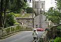 Kettlewell Beck bridge to Kettlewell Church

References
- ^ "YHA Kettlewell". YHA. 2009. Retrieved 20 May 2009.
External links
- Kettlewell Village Website
- Kettlewell
- Kettlewell Village Store
- The ancient parish of Kettlewell, historical and genealogical information at GENUKI
This North Yorkshire location article is a stub. You can help Wikipedia by expanding it. |