
Dooniver: Difference between revisions
Plasticspork (talk | contribs) fix |
Yurgenphogen (talk | contribs) No edit summary |
||
| Line 22: | Line 22: | ||
==Geography== |
==Geography== |
||
Dooniver is located on the east side of [[Achill Island]]. Surrounding villages include [[Askill]],Valley and [[Bunnacurry]]. |
Dooniver is located on the east side of [[Achill Island]]. Surrounding villages include [[Askill]],[[Tóin an tSeanbhaile|Valley]] and [[Bunnacurry]]. |
||
==Facilities== |
==Facilities== |
||
Revision as of 15:05, 16 March 2010
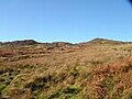
53°59′46″N 9°56′55″W / 53.9960°N 9.9486°W Template:Infobox Irish Place Dooniver is a village on Achill Island, Mayo.Dun Eibher as it is called in Gaeilge means Eibher's Fort. It has picturesque scenery. There are many beaches including Dooniver beach and Bullsmouth Beach. Surrounding villages include Askill,Bunnacurry, and The Valley. The island of Inishbiggle can be seen from Bullsmouth. Dooniver is a part of the Gaeltacht.
Geography
Dooniver is located on the east side of Achill Island. Surrounding villages include Askill,Valley and Bunnacurry.
Facilities
Dooniver has a hall, Garage, Plant Hire and Headstone maker.There is a Bed and Breakfast and caravan park.
Education
Dooniver has a National School (founded in 1910). The National School was originally in Bullsmouth, but was later moved. Students have a choice of going to either Scoil Damhnait or McHale College which is located in Pollranny in the Achill area.
Sport
Dooniver once had a football team called the which played in the [[Mayo & District League]. There is a GAA Pitch in the named St.Joesph's Park. Dooniver is a part of the St. Colman's (Dooniver, Askill, Valley, Dugort and Dookinella) local GAA team and the 'DVD' (Dugort, Valley, Dooniver) soccer team.
-
 Sea view looking onto Inishbiggle
 -
 Dun Eibher
 -
 Dooniver sign


