
Banburyshire: Difference between revisions
→Sport: ==Cherwell Edge== |
|||
| Line 5: | Line 5: | ||
==Banburyshire== |
==Banburyshire== |
||
[[File:Aynho.JPG|thumb|right|175px|Some old houses in [[Aynho]] (formerly spelt ''Aynhoe''), which is in Banburyshire.]] |
[[File:Aynho.JPG|thumb|right|175px|Some old houses in [[Aynho]] (formerly spelt ''Aynhoe''), which is in Banburyshire.]] |
||
| ⚫ | [[File:Banbury Bus firms.png|thumb|right|175px|A former [[Cheney Coaches]] bus, a Heyfordian bus, a Stagecoach bus and a '''Banburyshire Community Transport Association (B.C.T.A.)''' bus in Banbury. The Stagecoach busses ran every 15 minutes on weekdays and every 20 minutes at weekends as of 2008 and the Heyfordian bus runs every 30 minutes, except on Sundays as of 2009.]] |
||
'''Banburyshire''' is an informal (approximately 20 mile) area({{Coord|52.06278|1.33816|N|1|17|W|}}) <!-- Note: WGS84 lat/long, converted from OSGB36 grid ref. Region:GB_source:enwiki-osgb36(SP4547040696). --> of [[England]] that is centred on the [[market town]] of [[Banbury]]. The county of [[Oxfordshire]] has two main commercial centres, the city of [[Oxford]] itself that serves most of the south of the county, and Banbury that serves the north (such as [[Adderbury]], [[Deddington]], [[Wroxton]], [[Great Bourton]] and [[Bloxham]]) plus parts of the neighbouring counties of [[Northamptonshire]] and [[Warwickshire]].<ref>[http://www.banburyshireinfo.co.uk/ Community & news website for Banbury & Banburyshire]</ref><ref name="banburyshire.com">[http://www.banburyshire.com/ Banburyshire]</ref><ref>[http://www.mispedia.org/Banburyshire.html Banburyshire]</ref><ref>[http://networkbase.info/pageBanburyshire.html Banburyshire - Photos and All Basic Informations]</ref><ref>[http://www.banburyshireinfo.co.uk/banbury.html About Banbury North Oxfordshire, historic home of Banbury Cross]</ref><ref>[http://www.museumstuff.com/learn/topics/Banburyshire::sub::Gallery Banburyshire : Gallery]</ref><ref>[http://banter.cv31.co.uk/showthread.php?6338-Banburyshire&p=108441 Banburyshire]</ref><ref>[http://www.tripsage.com/p/1/3989243/banburyshire#p/1/3989243 Planning a trip to Banburyshire, Banbury, County of Oxfordshire, United Kingdom - TripSage]</ref> |
'''Banburyshire''' is an informal (approximately 20 mile) area({{Coord|52.06278|1.33816|N|1|17|W|}}) <!-- Note: WGS84 lat/long, converted from OSGB36 grid ref. Region:GB_source:enwiki-osgb36(SP4547040696). --> of [[England]] that is centred on the [[market town]] of [[Banbury]]. The county of [[Oxfordshire]] has two main commercial centres, the city of [[Oxford]] itself that serves most of the south of the county, and Banbury that serves the north (such as [[Adderbury]], [[Deddington]], [[Wroxton]], [[Great Bourton]] and [[Bloxham]]) plus parts of the neighbouring counties of [[Northamptonshire]] and [[Warwickshire]].<ref>[http://www.banburyshireinfo.co.uk/ Community & news website for Banbury & Banburyshire]</ref><ref name="banburyshire.com">[http://www.banburyshire.com/ Banburyshire]</ref><ref>[http://www.mispedia.org/Banburyshire.html Banburyshire]</ref><ref>[http://networkbase.info/pageBanburyshire.html Banburyshire - Photos and All Basic Informations]</ref><ref>[http://www.banburyshireinfo.co.uk/banbury.html About Banbury North Oxfordshire, historic home of Banbury Cross]</ref><ref>[http://www.museumstuff.com/learn/topics/Banburyshire::sub::Gallery Banburyshire : Gallery]</ref><ref>[http://banter.cv31.co.uk/showthread.php?6338-Banburyshire&p=108441 Banburyshire]</ref><ref>[http://www.tripsage.com/p/1/3989243/banburyshire#p/1/3989243 Planning a trip to Banburyshire, Banbury, County of Oxfordshire, United Kingdom - TripSage]</ref> |
||
| Line 19: | Line 20: | ||
===Transport=== |
===Transport=== |
||
| ⚫ | [[File:Banbury Bus firms.png|thumb|right|175px|A former [[Cheney Coaches]] bus, a Heyfordian bus, a Stagecoach bus and a '''Banburyshire Community Transport Association (B.C.T.A.)''' bus in Banbury. The Stagecoach busses ran every 15 minutes on weekdays and every 20 minutes at weekends as of 2008 and the Heyfordian bus runs every 30 minutes, except on Sundays as of 2009.]] |
||
The '''Banburyshire Community Transport Association Ltd''' charity provides special transport services for disabled in and around the town of Banbury.<ref>[http://www.banburyshire-cta.co.uk/ Banburyshire C.T.A. Ltd]</ref> |
The '''Banburyshire Community Transport Association Ltd''' charity provides special transport services for disabled in and around the town of Banbury.<ref>[http://www.banburyshire-cta.co.uk/ Banburyshire C.T.A. Ltd]</ref> |
||
Revision as of 09:55, 29 May 2011
This article possibly contains original research. (January 2011) |
This article needs additional citations for verification. (January 2011) |

Banburyshire


Banburyshire is an informal (approximately 20 mile) area(52.06278°1.33816′N 1°17′W / 52.08508267°N 1.283°W{{#coordinates:}}: invalid latitude) of England that is centred on the market town of Banbury. The county of Oxfordshire has two main commercial centres, the city of Oxford itself that serves most of the south of the county, and Banbury that serves the north (such as Adderbury, Deddington, Wroxton, Great Bourton and Bloxham) plus parts of the neighbouring counties of Northamptonshire and Warwickshire.[1][2][3][4][5][6][7][8]
From the former, the villages of King's Sutton and Middleton Cheney, and possibly also Aynho, Fenny Compton, Charlton and Croughton could be considered part of Banburyshire, and from the latter Upper and Lower Brailes also fall within Banbury's sphere of influence. Both the settlements of Bicester, Hinton-in-the-Hedges, Chipping Norton and Hook Norton are also on the border of Banburyshire's area.[2]
It is effectively encompassed by the former Banbury Rural District, Woodstock Rural District, Municipal Borough of Banbury, Southam Rural District, Brackley Rural District, Middleton Cheney Rural District and the north west of Ploughley Rural District (the part that was not in either Bicester Rural District or Headington Rural District befor 1931) local government areas, which were abolished between 1935 and 1974.
Roman finds
During excavations for the construction of an office building in Hennef Way in 2002, the remains of a British Iron Age settlement with circular buildings dating back to 200 BC were found. The site contained around 150 pieces of pottery and stone. Later there was a Roman villa at nearby Wykham Park.[9][10] Remains of a substantial Roman villa were been found just west of the B4100 main road, near Hanwell, Oxfordshire.[11][12] A Roman town once stood at Blacklands, 0.5 miles (800 m) north of the village of King Sutton[13][14] and coins from the 4th century AD have been alo been found there.[15]
Anglo-Saxon Chronicle
The Anglo-Saxon Chronicle recorded that Vikings raided the village of Hook Norton in AD 913.[16] Banburyshire, Warwickshire and Northamptonshire were on the Front line of the Viking/Anglo-Saxon conflict of that time.[16] and a parish church was built there by AD 922.[17] The Domesday Book records that in 1086 Hook Norton had 76 villagers and two mills.
Transport
The Banburyshire Community Transport Association Ltd charity provides special transport services for disabled in and around the town of Banbury.[18]
Sport
Cherwell Edge in Northamptonshire (52°6′N 1°17′W / 52.100°N 1.283°W) is near the River Cherwell, north-west of Banbury, England. The once heavily wooded hill and valley was mostly cleared by 1925 and the near by golf courses was biult in the early 1960s. The area now also covers the nearby Cherwell Edge Golf Club that was recently built by it to.[19][20] The golf club is used by various local residents and is one of Banburyshire's leading courses.
The Spiceball Centre is Banbury's recently upgraded sports centre, which includes a swimming pool, courts, café and gym facilities. It is also regarded as Banburyshire's leading facility of its kind.
Banbury United F.C. was first formed as Spencer Villa in 1931 and their home matches played at Middleton Road. At this time it was essentially a works club. In 1934, they changed their name to Banbury Spencer and moved to the Spencer Stadium. They had a lot of early success, winning most of the leagues which they played in.
See also
Gallery
-
![Hook Norton brewery is one of Britain's last working tower breweries (April 2006). The Anglo-Saxon Chronicle recorded that Vikings raided the village in AD 913[21] and a parish church was built there by AD 922.[22] The Domesday Book records that in 1086 Hook Norton had 76 villagers and two mills.](//upload.wikimedia.org/wikipedia/commons/thumb/0/0e/Hook_norton_brewery_1.jpg/95px-Hook_norton_brewery_1.jpg) Hook Norton brewery is one of Britain's last working tower breweries (April 2006). The Anglo-Saxon Chronicle recorded that Vikings raided the village in AD 913[21] and a parish church was built there by AD 922.[22] The Domesday Book records that in 1086 Hook Norton had 76 villagers and two mills.
Hook Norton brewery is one of Britain's last working tower breweries (April 2006). The Anglo-Saxon Chronicle recorded that Vikings raided the village in AD 913[21] and a parish church was built there by AD 922.[22] The Domesday Book records that in 1086 Hook Norton had 76 villagers and two mills. -
 The Almshouses in Chipping Norton.
 -
Bloxham's museum.
-
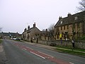 some old houses in Aynho (formerly spelt Aynhoe).
 -
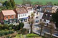 Kineton village centre.
 -
 Pittern Hill Windmill in Kineton.
 -
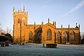 St Peter's Church in Kineton.
 -
 Great Bourton's Village Hall.
 -
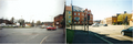 The "Shires" crossroads in 1999 to the left, prior to redevelopment in 2003, and the same place in 2009 to the right.
 -
-
 King's Sutton railway station was upgraded and re-gained it's footbridge in 2009.
 -
 A picture of King's Sutton in 2010.
 -

-
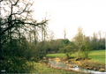
 The land around Banbury as seen from above, looking north-west.
 -
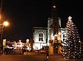 Banbury Town Hall at night.
 -
 The 'fine lady' and Banbury Cross.
 -
 A picture of Banbury Market.
 -
 A picture of Banbury Market.
 -
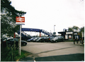
 A picture of Banbury station's car park. The Whiz Kids' Nursery and activity centre is in the background.
 -
 A picture of Banbury station. A E.W.S. freight rain and a Wrexham, Marylebone train are here to.
 -
 A picture of Banbury station. A Chiltern Railways Train arrives at Banbury railway station.
 -
 A picture of Banbury station. A former Wrexham, Shropshire and Marylebone Railway loco stabled at Banbury station.
 -
 A picture of Banbury station. The station's oil terminal.
 -
 A picture of a park in Easington estate in Banbury in 2001.
 -
 A 1911 Railway Clearing House map of railways in the vicinity of Banbury.
![Hook Norton brewery is one of Britain's last working tower breweries (April 2006). The Anglo-Saxon Chronicle recorded that Vikings raided the village in AD 913[21] and a parish church was built there by AD 922.[22] The Domesday Book records that in 1086 Hook Norton had 76 villagers and two mills.](/wiki/File:Hook_norton_brewery_1.jpg)


.png)
.png)
.png)


.png)
.png)
.png)
.png)


External links
- ^ Community & news website for Banbury & Banburyshire
- ^ a b Banburyshire
- ^ Banburyshire
- ^ Banburyshire - Photos and All Basic Informations
- ^ About Banbury North Oxfordshire, historic home of Banbury Cross
- ^ Banburyshire : Gallery
- ^ Banburyshire
- ^ Planning a trip to Banburyshire, Banbury, County of Oxfordshire, United Kingdom - TripSage
- ^ http://www.information-britain.co.uk/history/town/Banbury11/
- ^ A history of Banbury and the Banbury Cross explained
- ^ Lobel & Crosley, 1969, pages 112-123
- ^ Sherwood & Pevsner, 1974, page 632
- ^ Deegan & Foard, 2008, pages 118-119
- ^ Council for British Archaeology: South Midlands Region: Bedfordshire, Buckinghamshire, Northamptonshire & Oxfordshire
- ^ Pevsner & Cherry, 1973, page 279
- ^ a b Anglo-Saxons.net
- ^ St Peter's Parish Church history
- ^ Banburyshire C.T.A. Ltd
- ^ Cherwell Edge Golf Club in Oxfordshire - UK Golf Guide
- ^ Welcome To Cherwell Edge Golf Club
- ^ Anglo-Saxons.net
- ^ St Peter's Parish Church history