
Gimsøya: Difference between revisions
image, expansion |
references, external links |
||
| Line 1: | Line 1: | ||
[[File:Norway - Gimsøya.png|thumb|300 px|Gimsøya in Lofoten]] |
[[File:Norway - Gimsøya.png|thumb|300 px|Gimsøya in Lofoten]] |
||
'''Gimsøya''' is an island in [[Vågan]] municipality in [[Nordland]] county, Norway. |
'''Gimsøya''' is an island in [[Vågan]] municipality in [[Nordland]] county, Norway. <ref>[http://snl.no/Gims%C3%B8ya ''Gimsøya'' (Store Norske Lekiskon)]</ref> |
||
Gimsøya is situated between the islands of [[Austvågøya]] and [[Vestvågøya]] in the [[Lofoten] islands]. European route 10 passes through Gimsøya linking the island by the Sundklakkstraumen and Gimsoystraumen bridges with [[Austvågøya]] to the east and [[Vestvågøya]] to the west. The island has an area of 46,4 km² and a population of 230. |
|||
Gimsøya consists principally of Vinje (where Gimsøy Elementary school is located), Hov (where the golf course is located), Hovsund (where the marina and the abandoned fish factory is located), Barstrand (where some fishing industry is located), Gimsøysand (where Gimsøy church is located) and the Gjendalen. |
Gimsøya consists principally of Vinje (where Gimsøy Elementary school is located), Hov (where the golf course is located), Hovsund (where the marina and the abandoned fish factory is located), Barstrand (where some fishing industry is located), Gimsøysand (where Gimsøy church is located) and the Gjendalen. |
||
The southern and eastern part of Gimsøya is hilly. The highest point is 767 meters above sea level. In the north and west, the island is flat and marshy, with the exception of the mountain Hoven at 368 meters above sea level. There are large protected areas in Gimsøya related to fauna and bird life. Gimsøy marshes nature reserve (''Gimsøymyrene naturreservat'') is located on the island. |
The southern and eastern part of Gimsøya is hilly. The highest point is 767 meters above sea level. In the north and west, the island is flat and marshy, with the exception of the mountain Hoven at 368 meters above sea level. There are large protected areas in Gimsøya related to fauna and bird life. Gimsøy marshes nature reserve (''Gimsøymyrene naturreservat'') is located on the island. |
||
<gallery> |
<gallery> |
||
<gallery widths="100px" heights="100px"> |
<gallery widths="100px" heights="100px"> |
||
File:Sundklakkstraumen Bridge Lofoten 2009 - 2.JPG|Sundklakkstraumen Bridge |
|||
| ⚫ | |||
File:Gimsoystraumen Bridge Lofoten 2009.JPG|Gimsoystraumen Bridge |
|||
| ⚫ | |||
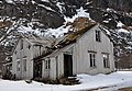
File:Abandoned house in Gimsøysand, Gimsøy Island, Lofoten, Norway.JPG|Abandoned house in Gimsøysand |
File:Abandoned house in Gimsøysand, Gimsøy Island, Lofoten, Norway.JPG|Abandoned house in Gimsøysand |
||
File:Shop and gas station on Gimsoy, Lofoten, Norway.jpg|Shop and gas station on Gimsoya |
File:Shop and gas station on Gimsoy, Lofoten, Norway.jpg|Shop and gas station on Gimsoya |
||
</gallery> |
</gallery> |
||
{{coord|68|18|N|14|12|E|display=title|region:NO_type:isle_source:GNS-enwiki}} |
{{coord|68|18|N|14|12|E|display=title|region:NO_type:isle_source:GNS-enwiki}} |
||
==Reference== |
|||
{{reflist}} |
|||
==External links== |
|||
*[http://norwaysaga2010.blogspot.com/2010/06/midnight-sun-on-gimsya.html Midnight Sun on Gimsøya] |
|||
[[Category:Islands of Nordland]] |
[[Category:Islands of Nordland]] |
||
Revision as of 04:59, 23 July 2011

Gimsøya is an island in Vågan municipality in Nordland county, Norway. [1]
Gimsøya is situated between the islands of Austvågøya and Vestvågøya in the [[Lofoten] islands]. European route 10 passes through Gimsøya linking the island by the Sundklakkstraumen and Gimsoystraumen bridges with Austvågøya to the east and Vestvågøya to the west. The island has an area of 46,4 km² and a population of 230.
Gimsøya consists principally of Vinje (where Gimsøy Elementary school is located), Hov (where the golf course is located), Hovsund (where the marina and the abandoned fish factory is located), Barstrand (where some fishing industry is located), Gimsøysand (where Gimsøy church is located) and the Gjendalen.
The southern and eastern part of Gimsøya is hilly. The highest point is 767 meters above sea level. In the north and west, the island is flat and marshy, with the exception of the mountain Hoven at 368 meters above sea level. There are large protected areas in Gimsøya related to fauna and bird life. Gimsøy marshes nature reserve (Gimsøymyrene naturreservat) is located on the island.
-
 Sundklakkstraumen Bridge
 -
 Gimsoystraumen Bridge
 -
 Gimsøy Church at Gimsøysand
 -
 Abandoned house in Gimsøysand
 -
 Shop and gas station on Gimsoya


68°18′N 14°12′E / 68.300°N 14.200°E