
Transylvanian Plain: Difference between revisions
Content deleted Content added
m Bot: Migrating 7 interwiki links, now provided by Wikidata on d:q1058238 (Report Errors) |
m ethnographic map removed |
||
| Line 1: | Line 1: | ||
{{for|the eponymous dance|Mezőség (dance)}} |
{{for|the eponymous dance|Mezőség (dance)}} |
||
[[Image:Mezoseg-CampiaTransilvaniei.png|thumb|left|The Transylvanian Plain]] |
|||
The '''Transylvanian Plain''' ([[Romanian language|Romanian]]: ''Câmpia Transilvaniei'', [[Hungarian language|Hungarian]]: ''Mezőség'') is an ethnogeographical area in [[Transylvania]], [[Romania]], located between the [[Someş River]] and the [[Mureş River]]. |
The '''Transylvanian Plain''' ([[Romanian language|Romanian]]: ''Câmpia Transilvaniei'', [[Hungarian language|Hungarian]]: ''Mezőség'') is an ethnogeographical area in [[Transylvania]], [[Romania]], located between the [[Someş River]] and the [[Mureş River]]. |
||
Revision as of 21:42, 22 May 2013
The Transylvanian Plain (Romanian: Câmpia Transilvaniei, Hungarian: Mezőség) is an ethnogeographical area in Transylvania, Romania, located between the Someş River and the Mureş River.
The Transylvanian Plain can be divided into two parts: a hilly one in the North-East and a plain one in South and West.
Some important villages of Câmpia Transilvaniei are Sic (a former salt-mining town), Mociu, Jucu, Band, Suatu and Unguraş.
Images
-
 Reformed Church in Beclean
 -
-
 Ceuaşu de Câmpie Reformed church and bell tower
 -
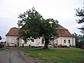
 Rascruci Banffy castle
 -
 Câmpeniţa Reformed Church
 -
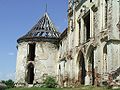
 Kornis Castle in Manastirea, Cluj
 -
 Voivodeni castle


External links
46°54′N 24°09′E / 46.900°N 24.150°E
This Romanian location article is a stub. You can help Wikipedia by expanding it. |
This Romania-related article is a stub. You can help Wikipedia by expanding it. |