
Oeffelt: Difference between revisions
m Bot: Migrating 2 interwiki links, now provided by Wikidata on d:q2656060 |
Sources: Geo - Google maps. Dialling code - Google 'netnummer Oeffelt'. Typos, style. |
||
| Line 3: | Line 3: | ||
|image_flag = Flag of Oeffelt.gif |
|image_flag = Flag of Oeffelt.gif |
||
|image_shield = Coat of arms of Oeffelt.gif |
|image_shield = Coat of arms of Oeffelt.gif |
||
|image_map = Map - NL - Boxmeer - Wijk 03 Oeffelt.svg |
|||
| ⚫ | |||
|map_caption = Boxmeer municipality, Oeffelt in pink |
|||
| ⚫ | |||
|subdivision_type = [[List of sovereign states|Country]] |
|subdivision_type = [[List of sovereign states|Country]] |
||
|subdivision_name = [[Netherlands]] |
|subdivision_name = [[Netherlands]] |
||
| Line 12: | Line 14: | ||
|population = 2340 |
|population = 2340 |
||
|population_as_of = 1 January 2009 |
|population_as_of = 1 January 2009 |
||
|dialling_code = |
|dialling_code = +31485 |
||
|postal_code = 5441 |
|postal_code = 5441 |
||
|latNS = N |
|latNS = N |
||
| Line 22: | Line 24: | ||
}} |
}} |
||
'''Oeffelt''' is a village in the [[Netherlands|Dutch]] province of [[North Brabant]] |
'''Oeffelt''' is a village in the [[Netherlands|Dutch]] province of [[North Brabant]], part of the [[Boxmeer]] municipality, about 5 km north of Boxmeer town and 6 km west of the border with the German province [[North Rhine-Westphalia]]. |
||
Oeffelt was a separate municipality until 1994, when it became part of Boxmeer.<ref>{{Repertorium Nederlandse Gemeenten}}</ref> |
Oeffelt was a separate municipality until 1994, when it became part of Boxmeer.<ref>{{Repertorium Nederlandse Gemeenten}}</ref> |
||
The |
The settlement Oeffelt was first mentioned in a document in 1075 as Uflo. This could be a combination from the Keltish words ''uffa'' (water) and ''ten'' (settlement), indicating a settlement by the [[Meuse (river)|Meuse river]], which nowadays runs between Oeffelt on the west bank and [[Gennep]] – in the province of [[Limburg (Netherlands)|Limburg]] – on the east bank. The villages are connected by a bridge in the [[N264]] road. |
||
== Gallery == |
== Gallery == |
||
<gallery> |
<gallery> |
||
Image:Oeffelt, monumentaal pand foto3 2011-03-08 11.27.JPG|Oeffelt, |
Image:Oeffelt, monumentaal pand foto3 2011-03-08 11.27.JPG|Oeffelt, monumental house |
||
Image:Oeffelt, kerk foto1 2011-03-08 11.32.JPG|Oeffelt, church |
Image:Oeffelt, kerk foto1 2011-03-08 11.32.JPG|Oeffelt, church |
||
</gallery> |
</gallery> |
||
Revision as of 17:24, 13 November 2014
Oeffelt | |
|---|---|
 Flag  Coat of arms | |
 Boxmeer municipality, Oeffelt in pink | |
| Country | Netherlands |
| Province | Noord-Brabant |
| Municipality | Boxmeer |
| Population (1 January 2009) | 2,340 |
Oeffelt is a village in the Dutch province of North Brabant, part of the Boxmeer municipality, about 5 km north of Boxmeer town and 6 km west of the border with the German province North Rhine-Westphalia.
Oeffelt was a separate municipality until 1994, when it became part of Boxmeer.[1] The settlement Oeffelt was first mentioned in a document in 1075 as Uflo. This could be a combination from the Keltish words uffa (water) and ten (settlement), indicating a settlement by the Meuse river, which nowadays runs between Oeffelt on the west bank and Gennep – in the province of Limburg – on the east bank. The villages are connected by a bridge in the N264 road.
Gallery
-
 Oeffelt, monumental house
 -
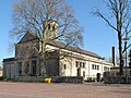 Oeffelt, church


References
- ^ Ad van der Meer and Onno Boonstra, Repertorium van Nederlandse gemeenten, KNAW, 2011.
External links
- Template:Kuyper Map of the former municipality, around 1868.
51°42′N 5°57′E / 51.700°N 5.950°E
This North Brabant location article is a stub. You can help Wikipedia by expanding it. |