Precipitation: Difference between revisions
m rv to Revision as of 05:34, 1 December 2006 by Hard Raspy Sci |
total precip flux + fraction over oceans |
||
| Line 2: | Line 2: | ||
[[Image:Regnbyge.jpg|240px|thumb|right|Late-summer rainstorm in Denmark]] |
[[Image:Regnbyge.jpg|240px|thumb|right|Late-summer rainstorm in Denmark]] |
||
In [[meteorology]], '''precipitation''' (also known as hydrometeor) is any form of [[water]] that falls from the sky as part of the [[weather]] to the ground. This includes [[snow]], [[rain]], [[sleet]], [[freezing rain]], [[hail]], and [[virga]]. Precipitation is a major component of the [[hydrologic cycle]], and is responsible for depositing most of the [[fresh water]] on the planet. |
In [[meteorology]], '''precipitation''' (also known as hydrometeor) is any form of [[water]] that falls from the sky as part of the [[weather]] to the ground. This includes [[snow]], [[rain]], [[sleet]], [[freezing rain]], [[hail]], and [[virga]]. Precipitation is a major component of the [[hydrologic cycle]], and is responsible for depositing most of the [[fresh water]] on the planet. Approximately 505,000 km³ of water fall as precipitation each year, 398,000 km³ of it over the oceans.<ref>Dr. Art's Guide to Planet Earth. [http://www.planetguide.net/book/chapter_2/water_cycle.html The Water Cycle.] Retrieved on 2006-10-24.</ref> |
||
==How precipitation forms== |
==How precipitation forms== |
||
Revision as of 19:04, 3 December 2006
- This article is about the meteorological term. For the chemistry term, see Precipitation (chemistry)

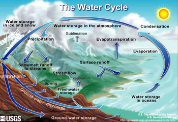
In meteorology, precipitation (also known as hydrometeor) is any form of water that falls from the sky as part of the weather to the ground. This includes snow, rain, sleet, freezing rain, hail, and virga. Precipitation is a major component of the hydrologic cycle, and is responsible for depositing most of the fresh water on the planet. Approximately 505,000 km³ of water fall as precipitation each year, 398,000 km³ of it over the oceans.[1]
How precipitation forms

Condensation
Precipitation begins forming when relatively warm, moist air rises. As the air cools, water vapor begins to condense on condensation nuclei, forming clouds. After the water droplets grow large enough, two processes can occur to form precipitation.
Coalescence
Coalescence occurs when water droplets merge to create larger water droplets, or when water droplets freeze onto an ice crystal. Because of air resistance, the water droplets in a cloud typically remain stationary. When air turbulence occurs, water droplets collide, producing larger droplets. As these larger water droplets descend, coalescence continues, so that drops become heavy enough to overcome air resistance and fall as rain. Coalescence generally happens most often in clouds above freezing.
Bergeron process
The Bergeron Process occurs when ice crystals acquire water molecules from nearby supercooled water droplets. As these ice crystals gain mass, they may begin to fall, acquiring more mass as coalescence occurs between the crystal and neighboring water droplets. This process is temperature dependent, as supercooled water droplets only exist in a cloud that is below freezing. In addition, because of the great temperature differential between cloud and ground level, these ice crystals may melt and become rain as they fall.
Precipitation
Precipitation is any product of the condensation of atmosphereic water vapour that is deposited on the earth's surface. Precipitation that forms aloft is divided into three categories:
Liquid Precipitation; Freezing Precipitation and Frozen Precipitation.
- Types of Freezing Precipitation:
- Freezing Drizzle (FZDZ)
- Freezing Rain (FZRA)
- Types of Frozen Precipitation:
- Snow (SN)
- Snow pellets (SHGS)
- Snow Grains (SG)
- Ice Pellets (PL)
- Hail (SHGR)
- Ice Crystals (IC)
The code in the brackets is the METAR Code for the phenomena
MANOBS Manual of Surface Weather Observations (Seventh, Amendment 15 ed.). Canada: Meteorological Service of Canada. 2006. {{cite book}}: Unknown parameter |origdate= ignored (|orig-date= suggested) (help)
Modes of precipitation
Convective precipitation

Convective, or showery, precipitation occurs from convective clouds, e.g., cumulonimbus or cumulus congestus. It falls as showers, with rapidly changing intensity and at one moment only over patches, as convective clouds have limited horizontal extent. Convective precipitation is most important in the tropics. Graupel and hail always indicate convection. In midlatitudes, convective precipitation is associated with cold fronts (often behind the front), squall lines, and warm fronts with significant available moisture.
Stratiform precipitation
Stratiform, or large-scale, precipitation occurs as a consequence of slow (cm/s) ascent of air in synoptic systems, such as along cold fronts, and in advance of warm fronts. Similar ascent is seen around Tropical cyclones outside of the eyewall, and in comma head precipitation patterns around mid-latitude cyclones.
Orographic precipitation

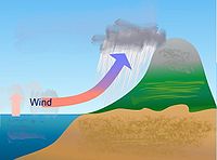
Orographic precipitation occurs on the windward side of mountains and is caused by the rising air motion of a large-scale flow of moist air across the mountain ridge, resulting in adiabatic cooling and condensation. In parts of the world subjected to relatively consistent winds (for example the trade winds), a wetter climate prevails on the windward side of a mountain than on the leeward (downwind) side as moisture is removed by orographic precipitation, leaving drier air (see katabatic wind) on the descending (generally warming), leeward side where a rain shadow is observed. Similarly, the interior of larger mountain zones is often quite dry, such as the Great Basin in North America.
Orographic precipitation is well known on oceanic islands, such as the Hawaiian Islands, where much of the rainfall received on an island is on the windward side, and the leeward side tends to be quite dry, almost desert-like, by comparison. This phenomenon results in substantial local gradients of average rainfall, with coastal areas receiving on the order of 500 to 750 mm per year (20 to 30 inches), and interior uplands receiving over 2.5 m per year (100 inches). Leeward coastal areas are especially dry 500 mm per year (20 inches)at Waikiki), and the tops of moderately high uplands are especially wet ~12 m per year (~475 inches) at Wai'ale'ale on Kaua'i).
Measurement of precipitation
The standard way of measuring rainfall or snowfall is the standard rain gage, which can be found in 4-inch/100 mm plastic and 8-inch/200 mm metal varieties. [2] The inner cylinder is filled by 25 mm/1 inch of rain, with overflow flowing into the outer cylinder. Plastic gages will have markings on the inner cylinder down to 0.25 mm/0.01" resolution, which metal gages will require use of a stick designed with the appropriate 0.25 mm/0.01" markings. After the inner cylinder is filled, the amount inside it is discarded, then filled with the remaining rainfall in the outer cylinder until all the fluid in the outer cylinder is gone, adding to the overall total until the outer cylinder is empty. These gages are winterized by removing the funnel and inner cylinder and allowing the snow/freezing rain to collect inside the outer cylinder. Once the snowfall/ice is finished accumulating, or as you approach 300 mm/12", one can either bring it inside to melt, or use luke warm water to fill the inner cylinder with in order to melt the frozen precipitation in the outer cylinder, keeping track of the warm fluid added, which is subsequently subtracted from the overall total once all the ice/snow is melted.
Other types of gages include the popular wedge gage (the cheapest rain gage and most fragile), the tipping bucket rain gage [3], and the weighing rain gage [4]. The wedge and tipping bucket gages will have problems with snow. Attempts to compensate for snow/ice by warming the tipping bucket meet with limited success, since snow may sublimate if the gage is kept much above freezing. Weighing gages with antifreeze should do fine with snow, but again, the funnel needs to be removed before the event begins. For those looking to measure rainfall the most inexpensively, a can that is cylindrical with straight sides will act as a rain gage if left out in the open, but its accuracy will depend on what ruler you use to measure the rain with. Any of the above rain gages can be made at home, with enough know-how. [5]
Once someone has a device to measure precipitation, various networks exist across the United States and elsewhere where rainfall measurements can be submitted through the internet, such as CoCoRAHS [6] or GLOBE [7]. If a network is not available in the area where one lives, the nearest local weather office will likely be interested in the measurement. [8] An important use of precipitation data is for forecasting of river flows and river water quality using hydrological transport models such as SWMM, SHE or the DSSAM Model.
Rainfall patterns in the United States
Western
Major elements are prevailing westerly winds and ocean currents moving toward the equator. At high latitudes the current is warmer than land, westerly winds take up moisture and cool when moving over land. When the land is warmer than the ocean, clouds do not produce precipitation, but accrete additional moisture, generating rain eventually at higher elevations. When the land is cooler than the ocean, then westerlies cool as they move inland and rain occurs in the lowlands.
Eastern and central
Polar air masses (above 50° latitude) are distinct from lower latitude air masses. The westerlies are warm air masses that move poleward from 30°N. In the eastern US the westerlies are often laden with moisture from Gulf of Mexico and Atlantic. When polar and westerly air masses meet, precipitation occurs.
Inland continental areas
Areas not proximate to large bodies of water warm more rapidly than coastal or lakeside regions. Hot air masses can rise from the center of the continent forming a low pressure area. This low pressure zone draws water laden clouds from the coasts. When this area warms, adiabatic change occurs and ultimately precipitation. The outcome is more summer rain, and less winter precipitation.
See also
References
- ^ Dr. Art's Guide to Planet Earth. The Water Cycle. Retrieved on 2006-10-24.
- ^ http://www.crh.noaa.gov/iwx/program_areas/coop/8inch.php
- ^ http://www.oardc.ohio-state.edu/williams.2157/Tipping_Bucket_Rain_Gage.htm
- ^ http://www.weather.gov/glossary/index.php?letter=w
- ^ http://school.discovery.com/lessonplans/activities/weatherstation/itsrainingitspouring.html
- ^ http://cocorahs.org
- ^ http://www.globe.gov/fsl/welcome/welcomeobject.pl
- ^ http://www.nws.noaa.gov
