Ohangaron District: Difference between revisions
Appearance
Content deleted Content added
m Don Alessandro moved page Okhangaron District to Ohangaron District |
No edit summary |
||
| Line 1: | Line 1: | ||
{{Infobox settlement |
{{Infobox settlement |
||
|name = |
|name =Ohangaron |
||
|settlement_type =[[Districts of Uzbekistan|District]] |
|settlement_type =[[Districts of Uzbekistan|District]] |
||
|official_name =Ohangaron tumani |
|official_name =Ohangaron tumani |
||
| Line 83: | Line 83: | ||
}} |
}} |
||
''' |
'''Ohangaron''' is a [[raion]] (district) of [[Tashkent Region]] in [[Uzbekistan]]. The capital lies at [[Ohangaron]]. |
||
== Settlements == |
== Settlements == |
||
Revision as of 22:09, 23 July 2020
Ohangaron | |
|---|---|
| Ohangaron tumani | |
| Country | Uzbekistan |
| Region | Tashkent Region |
| Capital | Okhangaron |
| Established | 1929 |
| Area | |
| • Total | 3,190 km2 (1,230 sq mi) |
| Population | |
| • Total | 78 100 |
| Time zone | UTC+5 (UZT) |
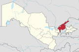
Ohangaron is a raion (district) of Tashkent Region in Uzbekistan. The capital lies at Ohangaron.
Settlements
There are one city (Ohangaron) and eight villages (Birlik, Doʻstlik, Ozodlik, Susam, Telov, Uvak, Qoraxitoy, Qurama).[1]
Population
78 100 people.

