Puketāpapa Local Board: Difference between revisions
changed the chair |
The Local Board map reference pointed to the Albert-Eden Puketapapa Ward boundary map. Changed it to the LB boundary map. |
||
| Line 98: | Line 98: | ||
The '''Puketāpapa Local Board''' is one of the 21 local boards of the [[Auckland Council]], and is one of the two boards overseen by the council's [[Albert-Eden-Roskill Ward]] councilors. |
The '''Puketāpapa Local Board''' is one of the 21 local boards of the [[Auckland Council]], and is one of the two boards overseen by the council's [[Albert-Eden-Roskill Ward]] councilors. |
||
The Puketāpapa board, named after the [[Māori language|Māori]] name for [[Mount Roskill]], covers the suburbs of [[Hillsborough, Auckland|Hillsborough]], [[Lynfield]], Mount Roskill, [[Three Kings, New Zealand|Three Kings]], [[Waikowhai]], and [[Wesley, New Zealand|Wesley]].<ref>{{cite web |url= |
The Puketāpapa board, named after the [[Māori language|Māori]] name for [[Mount Roskill]], covers the suburbs of [[Hillsborough, Auckland|Hillsborough]], [[Lynfield]], Mount Roskill, [[Three Kings, New Zealand|Three Kings]], [[Waikowhai]], and [[Wesley, New Zealand|Wesley]].<ref>{{cite web |url= https://www.aucklandcouncil.govt.nz/about-auckland-council/how-auckland-council-works/local-boards/all-local-boards/puketapapa-local-board/Documents/puketapapa-local-board-boundary-map.pdf |title= Puketāpapa Local Board map |accessdate= 27 October 2020}}</ref> The total population residing in the Puketāpapa Local Board area, as of {{NZ population data 2018|||y}}, is {{NZ population data 2018|Puketapapa local board area|y}}.<ref name="NZ_population_data_2018" /> |
||
The board is governed by six board members elected at-large. The first board members were elected by the [[2010 New Zealand local elections|nationwide local elections]], which were held on Saturday 9 October 2010. |
The board is governed by six board members elected at-large. The first board members were elected by the [[2010 New Zealand local elections|nationwide local elections]], which were held on Saturday 9 October 2010. |
||
Revision as of 06:52, 27 October 2020
Puketāpapa Local Board | |
|---|---|
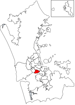
 Puketāpapa Local Board area in Auckland | |
| Country | New Zealand |
| Region | Auckland |
| Territorial authority | Auckland |
| Ward | Albert-Eden-Roskill Ward |
| Legislated | 2010 |
| Government | |
| • Board chair | Julie Fairey (RCV) |
Local Board Members | |
|---|---|
| Structure | |
4 / 6 | |
2 / 6 | |
| Elections | |
Last election | 2019 |
Next election | 2022 |
The Puketāpapa Local Board is one of the 21 local boards of the Auckland Council, and is one of the two boards overseen by the council's Albert-Eden-Roskill Ward councilors.
The Puketāpapa board, named after the Māori name for Mount Roskill, covers the suburbs of Hillsborough, Lynfield, Mount Roskill, Three Kings, Waikowhai, and Wesley.[2] The total population residing in the Puketāpapa Local Board area, as of June 2023, is .[1]
The board is governed by six board members elected at-large. The first board members were elected by the nationwide local elections, which were held on Saturday 9 October 2010.
The Puketāpapa board collaborated closely with Beca on the Hinaki Eel Trap Bridge.
2019–2022 term
The board members, elected at the 2019 local body elections, in election order:[3]
- Ella Kumar, C&R – Communities and Residents, (6528 votes)
- Julie Fairey, Roskill Community Voice, (6390 votes)
- Jon Turner, Roskill Community Voice, (6157 votes)
- Fiona Lai, C&R – Communities and Residents, (5956 votes)
- Bobby Shen, Roskill Community Voice, (5693 votes)
- Harry Doig, Roskill Community Voice, (5545 votes)
References
- ^ a b "Subnational population estimates (RC, SA2), by age and sex, at 30 June 1996-2023 (2023 boundaries)". Statistics New Zealand. Retrieved 25 October 2023. (regional councils); "Subnational population estimates (TA, SA2), by age and sex, at 30 June 1996-2023 (2023 boundaries)". Statistics New Zealand. Retrieved 25 October 2023. (territorial authorities); "Subnational population estimates (urban rural), by age and sex, at 30 June 1996-2023 (2023 boundaries)". Statistics New Zealand. Retrieved 25 October 2023. (urban areas)
- ^ "Puketāpapa Local Board map" (PDF). Retrieved 27 October 2020.
- ^ "Local board members" (PDF). Auckland Council. 18 October 2019. Retrieved 21 October 2019.
