
File:Map administrative divisions of the First French Empire 1812-en.svg

Original file (SVG file, nominally 2,052 × 1,728 pixels, file size: 4.14 MB)
| This is a file from the Wikimedia Commons. Information from its description page there is shown below. Commons is a freely licensed media file repository. You can help. |
Summary
| Description |
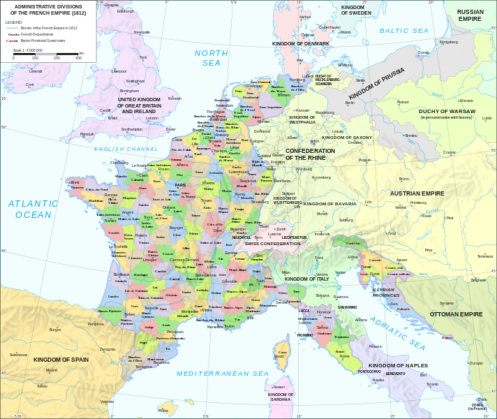
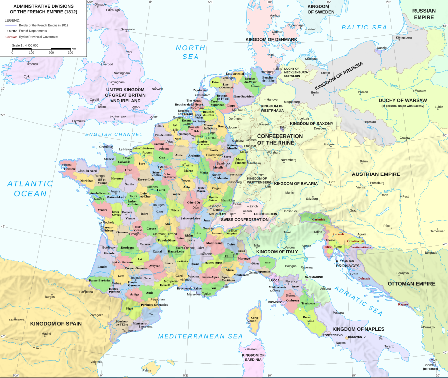
Català: Divisions administratives del Primer Imperi Francès el 1812
English: Administrative divisions of the First French Empire in 1812 |
| Date | |
| Source |
|
| Author | Andrein |
| Other versions |
Other related versions:[]
|


|
This SVG file contains embedded text that can be translated into your language, using any capable SVG editor, text editor or the SVG Translate tool. For more information see: About translating SVG files. |
This file is translated using SVG <switch> elements. All translations are stored in the same file! Learn more.
For most Wikipedia projects, you can embed the file normally (without a To translate the text into your language, you can use the SVG Translate tool. Alternatively, you can download the file to your computer, add your translations using whatever software you're familiar with, and re-upload it with the same name. You will find help in Graphics Lab if you're not sure how to do this. |
Licensing
- You are free:
- to share – to copy, distribute and transmit the work
- to remix – to adapt the work
- Under the following conditions:
- attribution – You must give appropriate credit, provide a link to the license, and indicate if changes were made. You may do so in any reasonable manner, but not in any way that suggests the licensor endorses you or your use.
- share alike – If you remix, transform, or build upon the material, you must distribute your contributions under the same or compatible license as the original.
File history
Click on a date/time to view the file as it appeared at that time.
| Date/Time | Thumbnail | Dimensions | User | Comment | |
|---|---|---|---|---|---|
| 19:42, 19 July 2015 |  | 2,052 × 1,728 (2.81 MB) | ArdadN | Liberation Serif | |
| 18:53, 19 July 2015 |  | 2,052 × 1,728 (2.82 MB) | ArdadN | 1 | |
| 18:41, 19 July 2015 |  | 2,052 × 1,728 (2.82 MB) | ArdadN | Deux Nethes dep. was missing | |
| 18:15, 19 July 2015 |  | 2,052 × 1,728 (2.81 MB) | ArdadN | small changes | |
| 18:06, 19 July 2015 |  | 2,052 × 1,728 (2.82 MB) | ArdadN | cropped | |
| 17:47, 19 July 2015 |  | 2,123 × 1,788 (2.8 MB) | ArdadN | map update | |
| 17:53, 19 February 2015 |  | 2,250 × 1,750 (3.77 MB) | ArdadN | Loire->Loir | |
| 14:22, 10 February 2015 |  | 2,250 × 1,750 (3.78 MB) | ArdadN | spelling corrections | |
| 12:44, 10 February 2015 |  | 2,250 × 1,750 (3.84 MB) | Andrei nacu | Val d'Aran to Haute Garonne | |
| 13:04, 28 February 2009 |  | 2,250 × 1,750 (3.85 MB) | Vinhtantran | {{Information |Description={{en|Own work.}} |Source=Transferred from [http://en.wikipedia.org en.wikipedia]; transfer was stated to be made by User:Vinhtantran. |Date=2008-10-23 (first version); 2008-07-13 (last version) |Author=Original uploader was |
File usage
- 130 departments of the First French Empire
- 1810s
- Bouches-del'Èbre
- Department of Segre
- Departments of France
- First French Empire
- History of the Netherlands
- Illyrian Provinces
- Kingdom of Italy (Napoleonic)
- Left Bank of the Rhine
- User:Dakaysaa/sandbox
- User:Falcaorib/France
- Portal:Maps/Maps/Political
- Portal:Maps/Maps/Political/14
Global file usage
The following other wikis use this file:
- Usage on af.wikipedia.org
- Usage on ar.wikipedia.org
- Usage on ca.wikipedia.org
- Usage on et.wikipedia.org
- Usage on fr.wikipedia.org
- Usage on hr.wikipedia.org
- Usage on it.wikipedia.org
- Usage on ka.wikipedia.org
- Usage on km.wikipedia.org
- Usage on no.wikipedia.org
- Usage on pl.wikipedia.org
- Usage on pnb.wikipedia.org
- Usage on pt.wikipedia.org
- Usage on ru.wikipedia.org
- Usage on tr.wikipedia.org
- Usage on ur.wikipedia.org
- Usage on vi.wikipedia.org