
File:Metro de Santiago.svg

Size of this PNG preview of this SVG file: 500 × 600 pixels. Other resolutions: 200 × 240 pixels | 400 × 480 pixels | 640 × 768 pixels | 853 × 1,024 pixels | 1,707 × 2,048 pixels | 1,500 × 1,800 pixels.
Original file (SVG file, nominally 1,500 × 1,800 pixels, file size: 1.17 MB)
| This is a file from the Wikimedia Commons. Information from its description page there is shown below. Commons is a freely licensed media file repository. You can help. |
Summary
| Description |
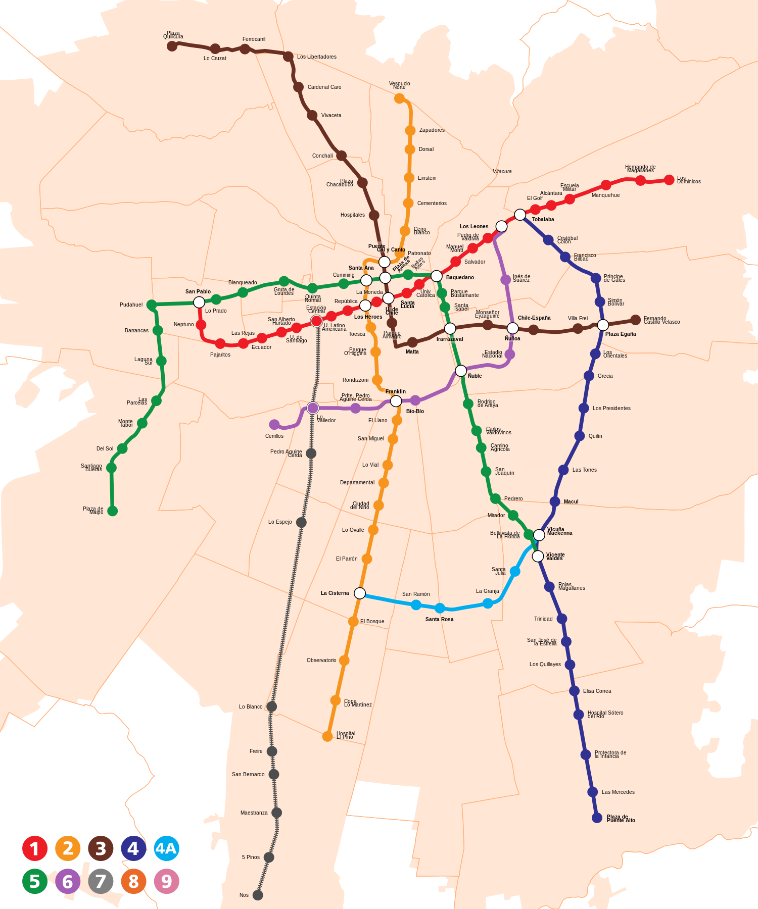
Español: Mapa de líneas y estaciones del Metro de Santiago, Chile. El mapa está a escala. Incluye servicios de tren de cercanías Metrotren. English: Map of lines and stations of the subway of Santiago, Chile (to scale). It includes the Metrotren suburban railway. |
| Date | |
| Source | |
| Author | B1mbo |
| Permission (Reusing this file) |
I, the copyright holder of this work, hereby publish it under the following license: This file is licensed under the Creative Commons Attribution-Share Alike 4.0 International license.
|
| Other versions |
 |

.svg)
.svg)
.svg)


File history
Click on a date/time to view the file as it appeared at that time.
| Date/Time | Thumbnail | Dimensions | User | Comment | |
|---|---|---|---|---|---|
| 19:46, 15 April 2007 |  | 700 × 800 (1.36 MB) | B1mbo | Reverted to an earlier version | |
| 19:36, 15 April 2007 |  | 700 × 800 (98 KB) | B1mbo | {{Information |Description={{es|Diagrama esquemático del Metro de Santiago, Chile, incluyendo las estaciones de intercambio ubicadas junto a las estaciones. El mapa no está a escala.}} |Source= Own design bas | |
| 05:57, 14 April 2007 |  | 700 × 800 (1.36 MB) | B1mbo | Few changes... Rasterized version | |
| 05:50, 14 April 2007 |  | 700 × 800 (166 KB) | B1mbo | Few changes... Non-rasterized version | |
| 00:32, 23 February 2007 |  | 700 × 800 (2.81 MB) | B1mbo | ||
| 02:35, 14 February 2007 |  | 350 × 400 (2.81 MB) | B1mbo | New version rasterized | |
| 02:21, 14 February 2007 |  | 350 × 400 (135 KB) | B1mbo | Correction... new stations eliminated in L1 and L5 | |
| 00:56, 23 December 2006 |  | 700 × 800 (2.88 MB) | B1mbo | To edit, use the first image uploaded and then convert the objects to traces. | |
| 23:40, 22 December 2006 |  | 350 × 400 (2.88 MB) | B1mbo | Letras y bordes rasterizados | |
| 23:23, 22 December 2006 |  | 350 × 400 (137 KB) | B1mbo | {{Information |Description={{es|Diagrama esquemático del Metro de Santiago, Chile. El mapa no está a escala.}}{{en|Schematic diagram of subway of Santiago, Chile.} |
File usage
The following 2 pages use this file:
Global file usage
The following other wikis use this file:
- Usage on ar.wikipedia.org
- Usage on be-tarask.wikipedia.org
- Usage on bg.wikipedia.org
- Usage on bn.wikipedia.org
- Usage on cs.wikipedia.org
- Usage on de.wikipedia.org
- Usage on de.wikivoyage.org
- Usage on en.wikivoyage.org
- Usage on eo.wikipedia.org
- Usage on es.wikipedia.org
- Usage on eu.wikipedia.org
- Usage on fa.wikipedia.org
- Usage on fi.wikipedia.org
- Usage on fr.wikipedia.org
- Métro de Santiago
- Ligne 4 du métro de Santiago
- Tobalaba (métro de Santiago)
- Cristóbal Colón (métro de Santiago)
- Francisco Bilbao (métro de Santiago)
- Príncipe de Gales (métro de Santiago)
- Simón Bolívar (métro de Santiago)
- Plaza Egaña (métro de Santiago)
- Las Torres (métro de Santiago)
- Macul (métro de Santiago)
- Fernando Castillo Velasco (métro de Santiago)
- Los Libertadores (métro de Santiago)
- Usage on he.wikipedia.org
- Usage on he.wikivoyage.org
- Usage on id.wikipedia.org
- Usage on is.wikipedia.org
- Usage on it.wikipedia.org
- Usage on ja.wikipedia.org
- Usage on ka.wikipedia.org
- Usage on nl.wikipedia.org
- Usage on no.wikipedia.org
- Usage on pl.wikipedia.org
- Usage on pl.wikivoyage.org
- Usage on pt.wikipedia.org
- Usage on sq.wikipedia.org
- Usage on sv.wikipedia.org
- Usage on th.wikipedia.org
- Usage on tr.wikipedia.org
View more global usage of this file.