
File:USRD FA map.png

Size of this preview: 800 × 496 pixels. Other resolutions: 320 × 198 pixels | 640 × 397 pixels | 1,024 × 635 pixels | 1,280 × 793 pixels | 3,219 × 1,995 pixels.
Original file (3,219 × 1,995 pixels, file size: 628 KB, MIME type: image/png)
Summary
[edit]| Description |
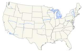
Map of Wikipedia:WikiProject U.S. Roads featured articles. Lines shown in blue represent roads with featured articles. States shaded blue have one or more featured articles on a statewide topic (i.e. system or state DOT articles).
| |||
|---|---|---|---|---|
| Source |
Created with US Census Bureau TIGER data and KML files linked from the articles depicted. | |||
| Date |
Initial creation August 7, 2012; updated as appropriate since then | |||
| Author | ||||
| Permission (Reusing this file) |
Since this is a map pertaining to the administration of the English Wikipedia only, it would be not be appropriate for a transfer to Commons. I, the copyright holder of this work, hereby publish it under the following license:
|


File history
Click on a date/time to view the file as it appeared at that time.
| Date/Time | Thumbnail | Dimensions | User | Comment | |
|---|---|---|---|---|---|
| 19:56, 1 May 2013 |  | 3,225 × 1,995 (575 KB) | Scott5114 (talk | contribs) | +M-* | |
| 09:25, 30 April 2013 |  | 3,217 × 2,002 (575 KB) | Scott5114 (talk | contribs) | +CA-67, modify Chickasaw Tpk. | |
| 19:06, 23 February 2013 |  | 3,307 × 2,031 (588 KB) | Scott5114 (talk | contribs) | +CA-52 | |
| 04:20, 18 January 2013 |  | 3,307 × 2,031 (587 KB) | Scott5114 (talk | contribs) | +CA-56 | |
| 08:41, 25 October 2012 |  | 3,307 × 2,031 (587 KB) | Scott5114 (talk | contribs) | +I-80 (IA), I-696 | |
| 03:40, 9 October 2012 |  | 3,307 × 2,031 (585 KB) | Scott5114 (talk | contribs) | +H-58 | |
| 00:40, 22 September 2012 |  | 3,244 × 2,032 (569 KB) | Scott5114 (talk | contribs) | +M-553 (again not that you can tell) | |
| 01:56, 13 August 2012 |  | 3,236 × 1,996 (569 KB) | Scott5114 (talk | contribs) | +CA-57—at least you can see this one | |
| 20:08, 10 August 2012 |  | 3,224 × 2,012 (568 KB) | Scott5114 (talk | contribs) | Add US-41 Bus in Michigan...not that you can tell... | |
| 22:22, 7 August 2012 |  | 3,240 × 2,016 (569 KB) | Scott5114 (talk | contribs) | {{keeplocal}} Map of Wikipedia:WikiProject U.S. Roads featured articles. Created with US Census Bureau TIGER data and KML files linked from the articles depicted. Since this is a map pertaining to the administration of the English Wikipedia only, ... |
You cannot overwrite this file.
File usage
The following pages on the English Wikipedia use this file (pages on other projects are not listed):