
Search results
- On the continent of Antarctica, the Aramis Range is the third range south in the Prince Charles Mountains, situated 11 miles southeast of the Porthos Range...23 KB (3,865 words) - 08:57, 26 November 2023
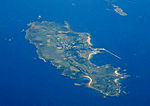 Burhou (pronounced ber-ROO) is a small island about 1.4 miles (2.3 km) northwest of Alderney that is part of the Channel Islands. It has no permanent residents...6 KB (643 words) - 15:30, 21 December 2023
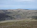 High Pike is a fell in the northern part of the English Lake District, it is located 4.5 kilometres (2+3⁄4 miles) south of Caldbeck. It has a height of...6 KB (681 words) - 10:37, 18 January 2024
- The Jennings River is a river in far northern British Columbia, Canada. It is approximately 150 kilometres (93 mi) long. The river was named for William...2 KB (309 words) - 15:50, 8 July 2023
 Binn Peak is the conspicuous rocky peak rising to 400 m above Miers Bluff at the southwest extremity of Hurd Peninsula, Livingston Island in the South...2 KB (255 words) - 19:08, 15 September 2023
 Odlezly Lake (Czech: Odlezelské jezero, sometimes Mladotické- or Potvorovské-) is the youngest lake in the Czech Republic. The lake and its surroundings...4 KB (364 words) - 07:23, 11 March 2024
- 54°32′24″N 3°20′02″W / 54.540°N 3.334°W / 54.540; -3.334 Buttermere and Ennerdale is a National Trust property located in the Lake District of Cumbria...862 bytes (86 words) - 01:27, 29 December 2023
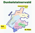 The Dunkelsteinerwald is a hill country south of the Danube in the Mostviertel region of Lower Austria. It is located at the shore of the Danube between...2 KB (201 words) - 14:12, 8 July 2022
- Rural–urban commuting areas (RUCAs) categorize U.S. census tracts based on measures of urbanization, population density, and daily commuting. RUCA codes...1 KB (139 words) - 06:27, 5 August 2022
- The Dos Bois River is a river of Goiás state in central Brazil. It is a tributary of the Crixás Açu River. List of rivers of Goiás Brazilian Ministry of...873 bytes (34 words) - 14:02, 17 February 2023
- The Da Prata River is a river of Minas Gerais state in southeastern Brazil. It is a tributary of the Tijuco River. List of rivers of Minas Gerais Map from...964 bytes (43 words) - 13:42, 17 February 2023
- The São João Surrá River is a river of Paraná state in southern Brazil. List of rivers of Paraná Brazilian Ministry of Transport v t e...966 bytes (26 words) - 13:56, 17 February 2023
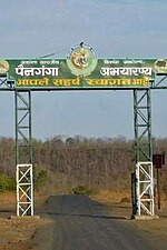 Painganga Wildlife Sanctuary is the name given to the protected forests on both sides of the Painganga River which divides Yavatmal district and Nanded...6 KB (631 words) - 19:48, 28 April 2023
 Crescent is a ghost town located on the west shore of North Manitou Island off the Leelanau Peninsula, in Leelanau County, Michigan. The small town was...8 KB (618 words) - 20:44, 9 May 2023
- The Little Lottery River is a river of the northeast of New Zealand's South Island. It flows southwest through the Amuri Range, flowing into the Lottery...1 KB (75 words) - 02:27, 13 April 2024
 Hütting is a parish village, part of the market municipality of Rennertshofen, in the district of Neuburg-Schrobenhausen, in the region of Upper Bavaria...4 KB (404 words) - 22:13, 20 October 2023


