
Search results
 The Merrimack Valley is a bi-state region along the Merrimack River in the U.S. states of New Hampshire and Massachusetts. The Merrimack is one of the...24 KB (2,301 words) - 06:09, 2 February 2024
 41°55′59″N 73°00′40″W / 41.933°N 73.011°W / 41.933; -73.011 The American Legion State Forest Trails is a system of Blue-Blazed hiking trails in the...9 KB (735 words) - 15:30, 13 April 2021
 The Menunkatuck Trail is an 11.0-mile (17.7 km) Blue-Blazed hiking trail in Guilford, Connecticut and, currently, is almost entirely on protected land...10 KB (975 words) - 14:11, 6 March 2023
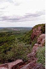 41°26′12.33″N 72°40′49.31″W / 41.4367583°N 72.6803639°W / 41.4367583; -72.6803639 The Mattabesett Trail is a 62-mile (100 km) long, hook-shaped blue-blazed...13 KB (1,458 words) - 12:32, 15 February 2024
 The Whitestone Cliffs Trail is a 1.7-mile (2.7 km) Blue-Blazed hiking trail in the Waterbury area in Thomaston and Plymouth, Litchfield County, Connecticut...11 KB (1,251 words) - 16:15, 19 March 2024
 The Salmon River Trail is a 6.9-mile (11.1 km) Blue-Blazed hiking trail in Colchester, and East Hampton, Connecticut and is almost entirely in the Salmon...9 KB (640 words) - 18:54, 9 January 2024
 The Westwoods Trails is an extensive hiking trail system in Guilford, Connecticut. The trail system has approximately 39 miles (63 km) of trails with features...5 KB (663 words) - 17:00, 28 April 2024


