
File:Serbo croatian languages2006.png
Size of this preview: 662 × 600 pixels. Other resolutions: 265 × 240 pixels | 530 × 480 pixels | 848 × 768 pixels | 1,130 × 1,024 pixels | 1,702 × 1,542 pixels.
Original file (1,702 × 1,542 pixels, file size: 188 KB, MIME type: image/png)
| This is a file from the Wikimedia Commons. Information from its description page there is shown below. Commons is a freely licensed media file repository. You can help. |
Summary
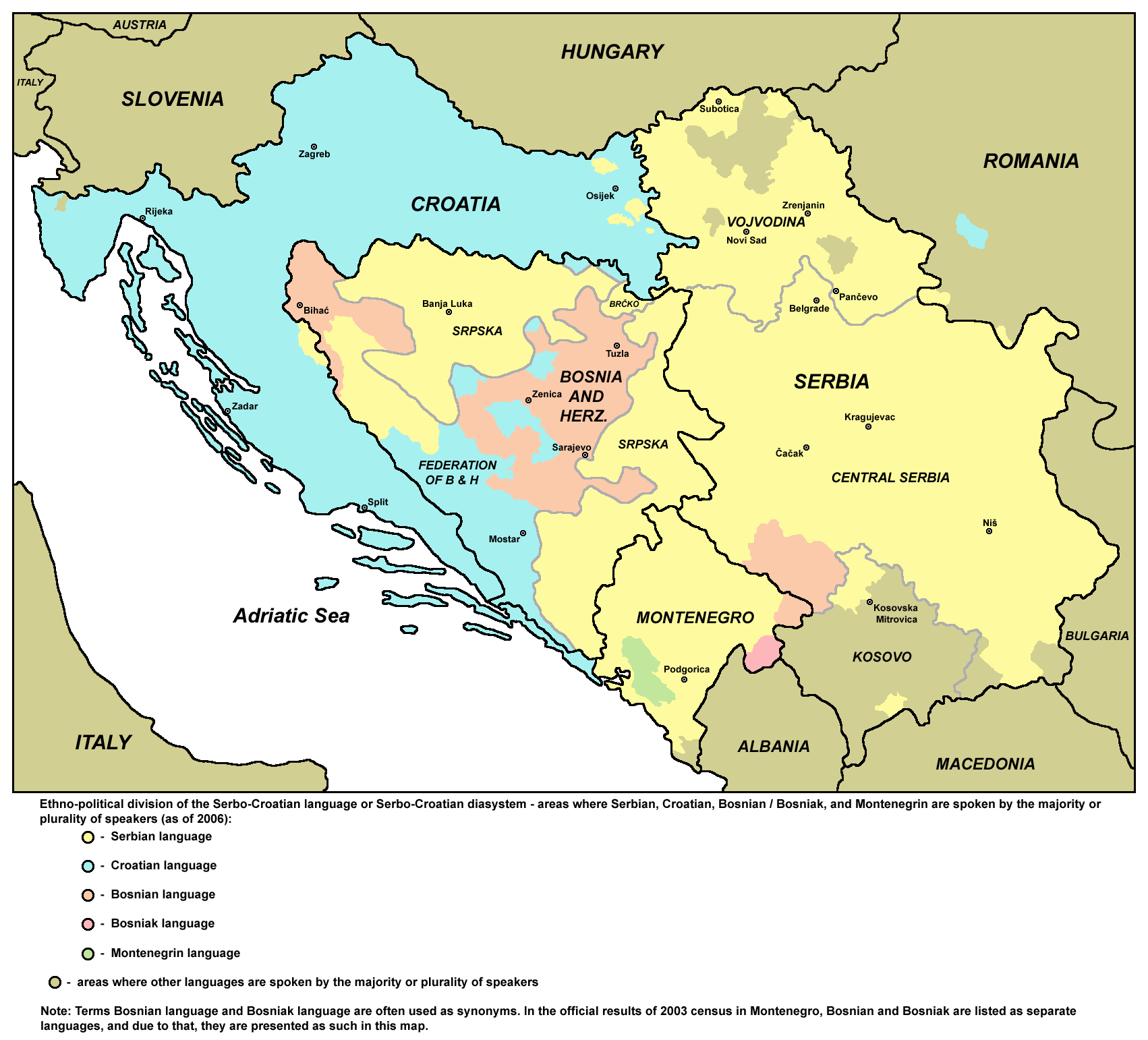
- English: Ethno-political division of the Serbo-Croatian language or Serbo-Croatian diasystem — areas where Serbian, Croatian, Bosnian/Bosniak, and Montenegrin are spoken by the majority or plurality of speakers (as of 2006) — data by municipalities.
- Serbo-Croatian: Etno-politička podela srpskohrvatskog jezika — područja na kojima apsolutna ili relativna većina stanovnika govori srpski, hrvatski, bosanski/bošnjački i crnogorski (2006. godina) — podaci po opštinama.
- Turkish: Etno-politik türevleri Sırp-Hırvatça veya Sırp-Hırvatlı diyasistemi (2006 itibariyle).
- Russian: Этно-политическое деление сербско-хорватского языка - районы, в которых абсолютное или относительное большинство населения говорит на сербском, хорватском, боснийском и черногорском языках (по состоянию на 2006) - данные по муниципалитетам.
References
Published references:
- Popis stanovništva, domaćinstava i stanova u 2002. - Stanovništvo - knjiga 3 - Veroispovest, maternji jezik i nacionalna ili etnička pripadnost prema starosti i polu (podaci po opštinama), Republika Srbija - Republički zavod za statistiku, Beograd, maj 2003.
- Popis stanovništva, domaćinstava i stanova u 2003. - Stanovništvo - knjiga 3 - vjeroispovest, maternji jezik i nacionalna ili etnička pripadnost prema starosti i polu (podaci po opštinama), Republika Crna Gora - Zavod za statistiku, Podgorica, novembar 2004.
Internet references:
- http://www.monstat.cg.yu/Popis/Popis03.zip - Crna Gora - Popis stanovništva, domaćinstava i stanova u 2003. - Stanovništvo - knjiga 3 - vjeroispovest, maternji jezik i nacionalna ili etnička pripadnost prema starosti i polu (podaci po opštinama).
- http://www.dzs.hr/ - Hrvatska - Popis stanovništva 2001. - STANOVNIŠTVO PREMA MATERINSKOM JEZIKU, PO GRADOVIMA/OPĆINAMA.
- http://www.edrc.ro/ - 2002 census in Romania.
- http://www.laser-dd.com/page.php?34%3Cbr%20/%3E - District Brčko population.
- http://commons.wikimedia.org/wiki/File:Kosovo_ethnic_2005.png
- http://www.michaeltotten.com/images/Kosovo%20Ethnic%20Map.JPG
- http://www.britannica.com/blogs/wp-content/uploads/2011/02/0000123909-kosovo011-0501.gif
- http://theeuropeans.net/blog/images/Kosovo_Map.gif
- http://www.vesti-online.com/data/images/2011-08-24/173718_mapa_iff.jpg?ver=1353141185
- http://commons.wikimedia.org/wiki/File:DemoBIH2006a.png
- http://commons.wikimedia.org/wiki/File:Etnicka_karta_BiH_iz_2005.gif
- http://img834.imageshack.us/img834/5324/bih2006i2008izbori.jpg
- http://www.crucified-kosovo.eu/attachments/Image/Maps/48_a_1994_etnicka_BiH.png
- http://www.euroheritage.net/bosniamap.PNG
- http://t2.gstatic.com/images?q=tbn:ANd9GcS2FkHib9v07XJKZWIjQVpx4t1mbdGqlgUxk4nHrKR2rzEztDqr
Licensing
Self-made map by PANONIAN
| This work has been released into the public domain by its author, PANONIAN. This applies worldwide. In some countries this may not be legally possible; if so: |
File history
Click on a date/time to view the file as it appeared at that time.
| Date/Time | Thumbnail | Dimensions | User | Comment | |
|---|---|---|---|---|---|
| 21:38, 16 June 2010 |  | 1,705 × 1,479 (173 KB) | WikiEditor2004 | Reverted to version as of 20:30, 26 April 2010 - reverted - these are not mistakes, but data made according to sources | |
| 14:28, 16 June 2010 |  | 1,705 × 1,479 (180 KB) | Ceha | Izmjena par grešaka: Mostar je jedinstvena općina, granice općine Žepče su malo sjevernije, a distrikt Brčko ne posjeduje unutarnju strukturu te je kao takav išaran hrvatskim, bošnjačkim i srpskim jezikom | |
| 20:30, 26 April 2010 |  | 1,705 × 1,479 (173 KB) | WikiEditor2004 | Reverted to version as of 20:58, 6 October 2009 | |
| 20:28, 26 April 2010 |  | 1,705 × 1,479 (173 KB) | WikiEditor2004 | reverted - this is municipality based data, please upload your map as separate file | |
| 19:50, 26 April 2010 |  | 1,705 × 1,479 (186 KB) | Olahus | At the level of localities. | |
| 20:58, 6 October 2009 |  | 1,705 × 1,479 (173 KB) | WikiEditor2004 | ||
| 16:32, 28 August 2009 |  | 1,705 × 1,479 (171 KB) | WikiEditor2004 | ==Description== *'''English:''' Areas where ethno-political variants of the Serbo-Croatian language or Serbo-Croatian diasystem are spoken by the majority or plurality of speakers (as of 2006). Note: political borders shown on this map are both, internati |
File usage
The following pages on the English Wikipedia use this file (pages on other projects are not listed):
Global file usage
The following other wikis use this file:
- Usage on ab.wikipedia.org
- Usage on af.wikipedia.org
- Usage on an.wikipedia.org
- Usage on ar.wikipedia.org
- Usage on arz.wikipedia.org
- Usage on ast.wikipedia.org
- Usage on avk.wikipedia.org
- Usage on az.wikipedia.org
- Usage on bat-smg.wikipedia.org
- Usage on ba.wikipedia.org
- Usage on be-tarask.wikipedia.org
- Usage on be.wikipedia.org
- Usage on bg.wikipedia.org
- Usage on bn.wikipedia.org
- Usage on br.wikipedia.org
- Usage on bs.wikipedia.org
- Usage on ceb.wikipedia.org
- Usage on ckb.wikipedia.org
- Usage on co.wikipedia.org
- Usage on csb.wikipedia.org
- Usage on cs.wikipedia.org
- Usage on cu.wikipedia.org
- Usage on cv.wikipedia.org
- Usage on cy.wikipedia.org
- Usage on da.wikipedia.org
- Usage on de.wikipedia.org
- Usage on dsb.wikipedia.org
View more global usage of this file.