
File talk:2022 Russian invasion of Ukraine.svg
![]() commons:File talk:2022 Russian invasion of Ukraine.svg
commons:File talk:2022 Russian invasion of Ukraine.svg
This page is a soft redirect.
Missing updates
Russian forces have entered Kyiv limits through Peremohy avenue: https://twitter.com/i/status/1497384243458101254 (also around Beresteiska Station: https://twitter.com/i/status/1497380272332963841) Other footage of distant fighting in Solom'yans'kyi district: https://twitter.com/i/status/1497380361797525507 — Preceding unsigned comment added by P4p5 (talk • contribs) 02:31, 26 February 2022 (UTC)
Russian military in tokmak according to live ua map
Mykolaiv offensive article claims that some force "managed to break through in Kakhovka on the Dnieper and are reported to be heading steadily towards Mykolaiv." RGoes (talk) 17:20, 26 February 2022 (UTC)
Detailed map from Twitter
Found new map with Russian gains in the north and east https://mobile.twitter.com/remilitari/status/1496908030545383429?cxt=HHwWisCy4Yf7isYpAAAA
Symbol
I think the square symbol should read "cities under siege" PastelKos (talk) 18:13, 25 February 2022 (UTC)
- Somewhat agreeing. Some clarity is needed. Cities in Ukraine pre-invasion is on the map sometimes shown as red dots if in occupied area, but what i presume is not in active fighting? This is not clear by the legend. Thus "cities under siege" makes more sense, or a synonym of that. Alseimik (talk) 22:38, 25 February 2022 (UTC)
Kyiv encircled
https://apnews.com/article/russia-ukraine-kyiv-europe-e9cd115540b398be26dfcaf472ec1621 Kyiv has been encircled confirms its mayor EnglishPoliticalPerson (talk) 21:48, 27 February 2022 (UTC)
Skadovsk and the rest of the Southern Peninsula is in Russian hands
Mark it as such on the maP — Preceding unsigned comment added by 206.174.216.170 (talk) 17:01, 28 February 2022 (UTC)
- Do you have a reliable source for that? Elijahandskip (talk) 17:18, 28 February 2022 (UTC)
Icons to represent Nuclear power plants
Hi, I've seen that Chernobyl plant is shown with a special nuclear power plant icon. However, other, operational nuclear power plants in Ukraine, for example the one at the bank of Dnipro in Enerhodar isn't shown. While it's understandable why Chernobyl would get special treatment in this regard, as it comes to this specific war, ALL Ukrainian nuclear power plants, their status, and their safeguarding, are of upmost significance for Ukraine, for Russia, and for the rest of Europe. I would like to ask if we can have the nuclear power plant icon can be added for the other plants in the country. BasilLeaf (talk) 03:51, 1 March 2022 (UTC) BasilLeaf (talk) 03:51, 1 March 2022 (UTC)
Pushbacks
@Viewsridge: When comparing with older versions, it appears that Russian forces lost control of some area north of Crimea, then wouldn't it make more sense to draw arrows from the Ukrainian side instead? This would make clear which side has gained control compared to previous days. Pieceofmetalwork (talk) 08:12, 1 March 2022 (UTC)
- @Pieceofmetalwork: Ukrainian counter-offensives have so far been limited to Kharkiv and Kiev's outskirts, large areas being colored into yellow from red were previously miscolored. I will add Ukrainian counter-attacks if a large scale one takes place. Viewsridge (talk) 08:48, 1 March 2022 (UTC)
Kherson is surrounded
https://twitter.com/IuliiaMendel/status/1498558161527132160 --So9q (talk) 09:57, 1 March 2022 (UTC)
map is waaay to conservative. it appears to be at least 2 days out of date .
This is true especially in the north. there have been reports of russians in Pryluky. Chernihiv is surrounded. Zaporizhzhia in the south is also attacked but isn't highlighted. etc Goggo2022 (talk) 18:43, 1 March 2022 (UTC)
scale
can you please start adding a scale to the map? — Preceding unsigned comment added by 92.76.39.141 (talk) 19:23, 1 March 2022 (UTC)
Does that not depend on the size of your screen?2001:4646:626A:0:41DC:1D5F:E013:3F76 (talk) 21:26, 1 March 2022 (UTC) Nevermid, think I misunderstood/mistranslated 2001:4646:626A:0:41DC:1D5F:E013:3F76 (talk) 21:28, 1 March 2022 (UTC)
thx — Preceding unsigned comment added by 92.76.39.141 (talk) 13:51, 3 March 2022 (UTC)
Colour coding for areas held before start of operations
Is it possible to colour code Crimea and Donbass areas that were already under Russian control before the start of the operations slightly differently from current advances (light pink/etc.) to help better visualise the progress of the Russians + Donbass troops? Thank you. Nebakin (talk) 04:08, 3 March 2022 (UTC)
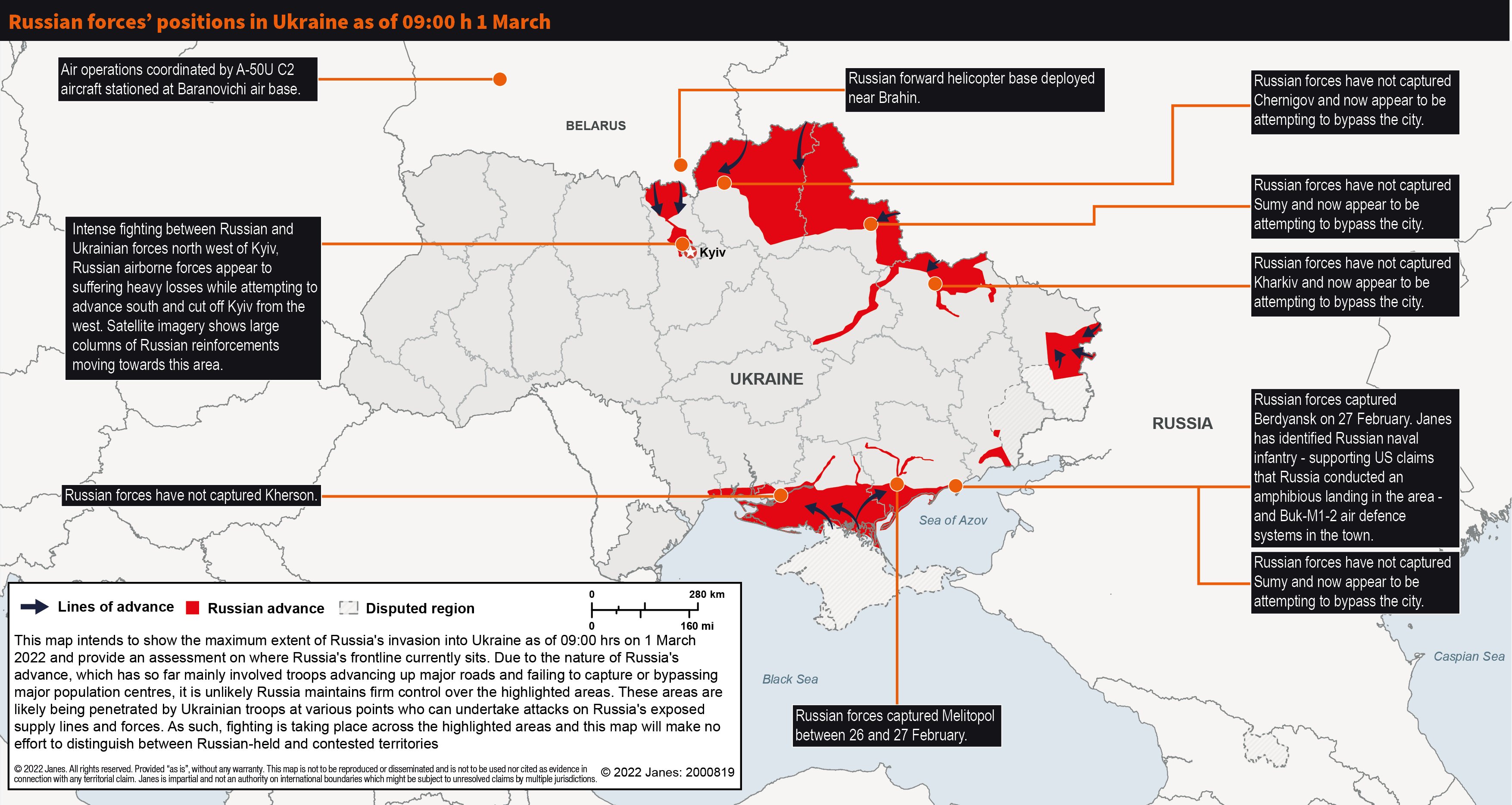
- Separate topic but is Jane's map being taken into consideration as well? For your reference: https://www.janes.com/images/default-source/advisor/russian-forces-positions-in-ukraine-as-of-0900h-1-march.jpg?sfvrsn=ddb12fdb_1 Nebakin (talk) 04:13, 3 March 2022 (UTC)
Time interval
Hello, terrific job on this map, very well done!
Would it be possible to add a tentative date of when the map was made/updated, instead of the "24 February 2022 - present" that is currently included? This would make easier to understand if we are looking at an updated map or not. --MassimoDellaPena (talk) 16:18, 3 March 2022 (UTC)