Jump to content

Tenderfoot Pass

Coordinates: 38°45′46″N 105°09′23″W / 38.76278°N 105.15639°W / 38.76278; -105.15639
From Wikipedia, the free encyclopedia

This is the current revision of this page, as edited by Jeffrey Beall (talk | contribs) at 22:03, 6 April 2022 (Added picture to infobox; one copy edit.). The present address (URL) is a permanent link to this version.

(diff) ← Previous revision | Latest revision (diff) | Newer revision → (diff)
Tenderfoot Pass
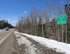
The pass and Highway 67
Elevation10,200 ft (3,109 m)
Traversed by SH 67
LocationTeller County, Colorado
United States
RangeFront Range
Coordinates38°45′46″N 105°09′23″W / 38.76278°N 105.15639°W / 38.76278; -105.15639
Tenderfoot Pass is located in Colorado
Tenderfoot Pass
Tenderfoot Pass
Location in Colorado

Tenderfoot Pass is a mountain pass northeast of Cripple Creek that reaches a peak elevation of 10,200 feet (3,100 m).

See also

[edit]
[edit]