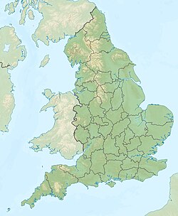
Keuper Waterstones
Appearance
| Keuper Waterstones | |
|---|---|
| Stratigraphic range: Anisian ~ | |
| Type | Formation |
| Unit of | Mercia Mudstone Group |
| Lithology | |
| Primary | Sandstone |
| Location | |
| Coordinates | 53°00′N 1°12′W / 53.0°N 1.2°W |
| Approximate paleocoordinates | 16°00′N 11°24′E / 16.0°N 11.4°E |
| Region | England |
| Country | |
The Keuper Waterstones is a geologic formation in England. It preserves ichnofossils of Varanopus aff. curvidactylus, Swinnertonichnus mapperleyensis, Deuterotetrapous plancus, Chirotherium swinnertoni, Microsauropus acutipes and Erpetopus willistoni dating back to the Middle Triassic (Anisian) period.[1]
See also
[edit]References
[edit]- ^ Keuper Waterstones at Fossilworks.org
Further reading
[edit]- W. A. S. Sarjeant. 1967. Fossil footprints from the Middle Triassic of Nottinghamshire and Derbyshire. The Mercian Geologist 2:327-341
- H. H. Swinnerton. 1910. Organic remains in the Trias of Nottingham. Geological Magazine, decade 5 7(5):229


