Theisseil
Appearance
Theisseil | |
|---|---|
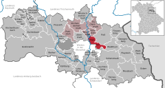
Location of Theisseil within Neustadt a.d.Waldnaab district  | |
| Coordinates: 49°42′N 12°14′E / 49.700°N 12.233°E | |
| Country | Germany |
| State | Bavaria |
| Admin. region | Oberpfalz |
| District | Neustadt a.d.Waldnaab |
| Municipal assoc. | Neustadt an der Waldnaab |
| Government | |
| • Mayor (2022–28) | Johannes Kett[1] (CSU) |
| Area | |
| • Total | 21.40 km2 (8.26 sq mi) |
| Elevation | 557 m (1,827 ft) |
| Population (2023-12-31)[2] | |
| • Total | 1,221 |
| • Density | 57/km2 (150/sq mi) |
| Time zone | UTC+01:00 (CET) |
| • Summer (DST) | UTC+02:00 (CEST) |
| Postal codes | 92637 |
| Dialling codes | 09602 0961 |
| Vehicle registration | NEW |
Theisseil is a municipality in the district of Neustadt an der Waldnaab in Bavaria, Germany.
References
[edit]- ^ Liste der ersten Bürgermeister/Oberbürgermeister in kreisangehörigen Gemeinden, Bayerisches Landesamt für Statistik, 19 October 2022.
- ^ Genesis Online-Datenbank des Bayerischen Landesamtes für Statistik Tabelle 12411-003r Fortschreibung des Bevölkerungsstandes: Gemeinden, Stichtag (Einwohnerzahlen auf Grundlage des Zensus 2011).


