Eribe
Appearance
Eribe | |
|---|---|
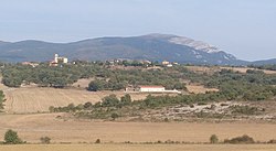
 View of Eribe with Gorbea in the background | |
| Coordinates: 42°57′23″N 2°42′38″W / 42.95639°N 2.71056°W | |
| Country | Spain |
| Autonomous community | Basque Country |
| Province | Álava |
| Comarca | Gorbeialdea |
| Municipality | Zigoitia |
| Area | |
| • Total | 3.72 km2 (1.44 sq mi) |
| Elevation | 640 m (2,100 ft) |
| Population (2022)[1] | |
| • Total | 65 |
| • Density | 17/km2 (45/sq mi) |
| Postal code | 01138 |
Eribe is a hamlet and concejo located in the municipality of Zigoitia, in Álava province, Basque Country, Spain. The parish church, dedicated to Saint Martin, contains pre-Romanesque elements; although most of it was built in later periods.[2]
References
[edit]- ^ "Nomenclátor: Núcleos". Entidades Locales de Álava (in Spanish). Diputación Foral de Álava. 1 January 2022. Retrieved 28 November 2023.
- ^ "Nuestros Pueblos". Ayuntamiento de Zigoitia (in Spanish). Retrieved 28 November 2023.
External links
[edit] Media related to Eribe at Wikimedia Commons


