Matunga (Penrhyn)
Appearance

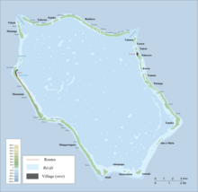
Matunga, also known as Morokai, is an islet in Penrhyn Atoll (Tongareva) in the Cook Islands, in the South Pacific Ocean.[1] The islet is in the northwest of the atoll, just south of Tekasi. Matunga contains the ruins of a marae, Kirihuri, as well as a ruined church. It was one of the missionary villages depopulated by Peruvian slavers.[2]
In 1890 after an outbreak of leprosy the island was used as a leper colony and was renamed "morokai".[3] The remaining lepers were evacuated to Fiji in 1929.[4]
References[edit]
- ^ Liu Chuang; Shi Ruixiang; Chen Lijun (January 2019). "Penrhyn Atoll". Institute of Geographical Sciences and Natural Resources Research, Chinese Academy of Sciences. Retrieved 10 August 2020.
- ^ Te Rangi Hiroa (April 1932). Ethnology of Tongareva. Honolulu: Bernice P. Bishop Museum. p. 159. Retrieved 21 August 2020 – via NZETC.
- ^ Benjamin Kingsbury (2019). The Dark Island: Leprosy in New Zealand and the Quail Island Colony. Wellington: Bridget Williams Books. p. 11.
- ^ Hiroa (1932), p. 82
8°56′11.71″S 158°2′54.2″W / 8.9365861°S 158.048389°W
