
Saint-Denis, Mons
Saint-Denis
Sint-Dnis (Walloon) | |
|---|---|
 The village in the spring | |
 Coat of arms | |
Location of Saint-Denis  | |
 Location of Saint-Denis in Mons | |
 Saint-Denis  Saint-Denis | |
| Coordinates: 50°29′31″N 4°01′05″E / 50.49194°N 4.01806°E | |
| Country | |
| Community | |
| Region | |
| Province | |
| Arrondissement | Mons |
| Municipality | Mons |
| Postal codes | 7034 |
| Area codes | 065 |
Saint-Denis (French pronunciation: [sɛ̃ dəni] ; Walloon: Sint-Dnis) is a sub-municipality of the city of Mons located in the province of Hainaut, Wallonia, Belgium. It was a separate municipality until 1964. In 1964, it was merged into Obourg. On 1 January 1972, Obourg was merged into Mons.[1]
Gallery
-
 Water mill (18th century).
 -
 Church.
 -
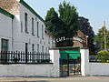 The « Café de la Rampe ».
 -
 Pond.
Pond. -
 Vineyard.
 -
 Abbey Farm.
_JPG01.jpg)
_JPG00.jpg)
_JPG02.jpg)
_-_%C3%89tang_de_l%27abbaye_2.JPG)


References
- ^ Arrêté royal du 18 février 1971 portant fusion des communes de Mons, Cuesmes, Ghlin, Hyon, Nimy et Obourg.
Wikimedia Commons has media related to Saint-Denis (Mons).
This Hainaut Province location article is a stub. You can help Wikipedia by expanding it. |