
Steall Waterfall
| Steall Waterfall | |
|---|---|
| An Steall Bàn | |
 Steall Waterfall | |
 | |
 | |
| Location | Fort William, Highland, Scotland |
| Coordinates | 56°46′11″N 4°58′43″W / 56.7698°N 4.9786°W |
| Type | Tiered |
| Total height | 120 m / 393 ft |
| Watercourse | Allt Coire a' Mhail |
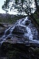
Steall Waterfall, also known as An Steall Bàn or Steall Falls, is situated in Glen Nevis near Fort William, Highland, Scotland. It is Scotland's second-highest waterfall, with a single drop of 120 metres (390 feet).[1] The falls can be viewed from the path that runs through the Nevis Gorge, an area owned by the John Muir Trust which manages the area for its wilderness qualities. An Steall Bàn means "The White Spout" in Gaelic
See also
References
- ^ "Steall Falls – A Glen Nevis Adventue". Lochaber Chamber of Commerce. Retrieved 20 March 2018.
-
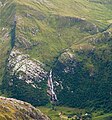 View from Ben Nevis
 -

-


This Highland location article is a stub. You can help Wikipedia by expanding it. |