Jump to content

Phong Thạnh Tây B

Coordinates: 9°20′13″N 105°19′22″E / 9.33694°N 105.32278°E / 9.33694; 105.32278
From Wikipedia, the free encyclopedia

This is the current revision of this page, as edited by Waseemtambewiki (talk | contribs) at 23:53, 17 March 2024 (top: Added image and caption #suggestededit-add-image-infobox). The present address (URL) is a permanent link to this version.

(diff) ← Previous revision | Latest revision (diff) | Newer revision → (diff)
Phong Thạnh Tây B
Rural commune and village
Phong Thạnh
Phong Thạnh
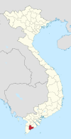
Map
Country Vietnam
ProvinceBạc Liêu
DistrictPhước Long
Time zoneUTC+07:00 (Indochina Time)

Phong Thạnh Tây B is a rural commune () and village in Phước Long District, Bạc Liêu Province, in south-western Vietnam.[1]

References

[edit]

9°20′13″N 105°19′22″E / 9.33694°N 105.32278°E / 9.33694; 105.32278