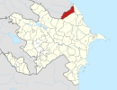
Mucuqoba
Appearance
This article relies largely or entirely on a single source. (June 2024) |
Mucuqoba | |
|---|---|
Village | |
| Coordinates: 41°40′39″N 48°30′04″E / 41.67760°N 48.50110°E | |
| Country | |
| Rayon | Qusar |
| Time zone | UTC+4 (AZT) |
| • Summer (DST) | UTC+5 (AZT) |
Mucuqoba is a village in the municipality of Aşağı İmamqulukənd in the Qusar Rayon of Azerbaijan.[1]
References
[edit]- ^ "Belediyye Informasiya Sistemi" (in Azerbaijani). Archived from the original on 24 September 2008.


