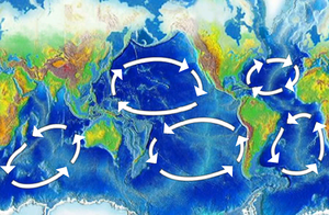
Boundary current
This article includes a list of references, related reading, or external links, but its sources remain unclear because it lacks inline citations. |
Boundary currents are defined as ocean currents with dynamics determined by the presence of a coastline, and fall into two specific categories: Western boundary currents, and Eastern boundary currents. There are many differentiating specifications between the two.
Eastern boundary currents
Eastern boundary currents typically cover a wide region, have a moderate amount of strength, are shallow, and slow flowing ocean currents. They are found on the Eastern side of oceanic basins, which contrary to their directional description, reside in the western regions of the world. Examples are the Benguela Current and the Canary Current as well as the California Current. Eastern boundary currents are associated with coastal upwelling and a subsurface countercurrent along the continental slope. These currents are integral to the circulation of the ocean's water. Because the rotation of the Earth causes an accumulation of energy on the western side of the Earth, that energy is dissipated in the western boundary current. There is no similar energy dissipation on the eastern side, thus making eastern boundary currents slow moving and broad.They are responsible for transporting cool temperature, high latitude water to lower latitudes. The average movement of ocean water at all depths, the Ekman transport, is 90° to the right of the wind in the Northern Hemisphere, and 90° to the left in the Southern Hemisphere. When these currents transport water away from a coast, it creates an upwelling of deep, nutrient-rich sea water.
Western boundary currents
A western boundary current is a warm, deep, narrow, and fast flowing current that occurs on the west side of an ocean basin. They are important in climate control by bringing warm water from the equator poleward. Its narrowness results from the displacement of the geostrophic "hill" to the western side of ocean basins due to Coriolis effect, compressing the currents on this side. Examples include the Gulf Stream, the Agulhas current, and the Kuroshio current.
Western intensification
Western intensification is the intensification of the western arm of an oceanic current, particularly a large gyre in an ocean basin, due to the Coriolis effect, and the variation of Coriolis force with latitude (the beta effect). It is for this reason that the currents on the western boundary of a basin (such as the Gulf Stream, a current on the western side of the Atlantic Ocean) are stronger than those on the eastern boundary (such as the California Current, on the eastern side of the Pacific Ocean). First explained by the American oceanographer Henry Stommel.
The cause is at least partially, if not mostly the difference in the Coriolis effect at different latitudes. Coriolis effect is stronger nearer the poles, so as the North Atlantic Current is driven east by the Westerly Winds, it wants to curve to the right, or South toward the center of the North Atlantic Gyre becoming the broad Canary Current. The Canary Current also wants to curve to the right toward the center of the gyre broadening the current even further. The North Equatorial Current heading west has the least influence from Coriolis effect and the water literally piles up along the western side of the basin (which can be seen by looking at a sea surface elevation satellite data picture). The Gulf Stream flows north out of this pile of water in a narrow intense current.
See also
References
- Thurman, Harold V., Trujillo, Alan P. Introductory Oceanography Tenth Edition. ISBN 0-13-143888-3
- AMS glossary: amsglossary.allenpres.com
- Professor Raphael Kudela, UCSC, lectures OCEA1 Fall 2007

