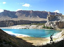
Band-e Amir National Park


Band-e Amir (Persian: بند امیر, meaning "Dam of the Amir") refers to five lakes high in the Hindu Kush Mountains of Central Afghanistan at approximately 3000 meters elevation, west of the famous Buddhas of Bamiyan. They were created by the carbon dioxide rich water oozing out of the faults and fractures to deposit calcium carbonate precipitate in the form of travertine walls that today store the water of these lakes.
History
Band-e Amir was to become Afghanistan's first national park in the 1960s, but due to the instability of the Kabul government at the time, this did not happen. In 2004, Band-e Amir was submitted for recognition as a World Heritage site.[1] In 2008, Band-e Amir was finally declared Afghanistan's first national park.[2]
-
One of the Lakes at Band-e Amir Area.
-
Another Lake at Band-e Amir Area.
Geography
Band-e Amir is situated at approximately 75 kilometers to the north-west of the ancient city of Bamyan, close to the town of Yakawlang. Together with Bamiyan, they are the heart of Afghanistan's tourism, attracting thousands of tourists every year and from every corner of the world[citation needed]. The six constituent lakes of Band-e Amir are:
- Band-e Gholaman (slaves)
- Band-e Qambar (Caliph Ali's slave)
- Band-e Haibat (grandiose)
- Band-e Panir (cheese)
- Band-e Pudina (wild mint)
- Band-e Zulfiqar (the sword of Ali)
Band-e Haibat is the biggest and the deepest of the six, with an average depth of approximately 150 meters, as estimated by the PRT diving team from New Zealand.
The white travertine dams created by fault lines, which are prevalent in the Band-e Amir Valley, form the barriers between the lakes.
Another comparable lake is Band-e Azhdar (The Dragon), located a few kilometres southeast of the town of Bamyan, which has also been created as a result of carbon dioxide rich water oozing out of the faults underground and depositing calcium carbonate precipitate to form the travertine walls of Band-e Amir.
The Band-e Amir lakes are primarily a late spring and summertime tourism destination, as the high elevation central Hazarajat region of Afghanistan is extremely cold in winter, with temperatures reach as low as -20C.
The world known 1975 film Dharmatma by Feroz Khan and Hema Malini was filmed in Band E Amir.
Concerns
The problems facing the visitors are harsh terrain, rocky plateau, lack of basic facilities and mined unpaved roads. The surrounding roads were heavily mined by the local militias and the Taliban during their respective reigns. Only a thin track is clear from mines and is in use by traffic.
The only available bazaar is a tiny one situated by the side of Band-e Haibat, where a couple of basics can be purchased.
Due to the lack of attention and the absence of any maintenance authority, increasing number of visitors pose a threat to the ecological balance of these lakes which include unregulated grazing and uprooting of shrubs which can result in serious soil erosion and even landslides. Fishing using electricity from mobile generators and explosives such as grenades has damaged the aquatic ecosystem. According to the Wildlife Conservation Society, much of the park's wildlife has been lost.[3] Due to lack of funding for waste management, human waste and trash has led to increasing pollution. In 2008 the Afghan government banned the use of boats with gasoline engines on the lakes.
References
- ^ Band-E-Amir - UNESCO World Heritage Centre. Submitted on 2004-09-08. Retrieved on 2008-07-15 from http://whc.unesco.org/en/tentativelists/1946/.
- ^ Leithead, Alastair (2008-07-15). Getting tourists to Afghanistan's 'Grand Canyon'. BBC News. Retrieved on 2008-07-15 from http://news.bbc.co.uk/2/hi/south_asia/7506146.stm.
- ^ Afghans get first national park, BBC News, 22 April 2009
Bibliography
- Dupree, Nancy Hatch (1977): An Historical Guide to Afghanistan. 1st Edition: 1970. 2nd Edition. Revised and Enlarged. Afghan Tourist Organization. LINK


