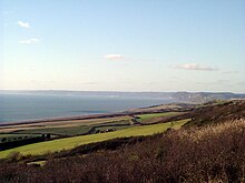
Golden Cap

Golden Cap is a hill and cliff situated between Bridport and Charmouth in Dorset, England. The cliffs are the highest point on the south coast of Great Britain. The hill is owned by the National Trust and forms part of the Jurassic Coast, a World Heritage Site. The name derives from the distinctive outcropping of golden Greensand rock present at the very top of the cliff.
Golden Cap is the highest point on the south-coast of Great Britain. The 626 ft (191 m) hill is visible for tens of miles in each direction along the coastline. There is a coast-path leading up from Seatown and for those fit enough to try, it takes about 30 to 40 minutes to get to the top. Directly behind the cliff is a small wood of (mainly) Corsican Pine known as Langdon Wood, planted in the 1950s and originating from a copse of trees known as "Eleanor's Clump". Langdon is owned by the National Trust and has a car park and a circular walk around the wood of almost exactly one mile.
The base of the cliff is shrouded by various large boulders, which are frequented by fossil collectors and tourists alike. Following a storm, thousands of fossilised ammonites and belemnites are visible in the Blue Lias base. The base of the cliff is accessible through Chideock Beach (Seatown) or Charmouth. Extreme caution must be taken when visiting the base of Golden Cap, as the tide completely envelopes the beach below the cliff. A secondary but not insignificant danger is of rock falls, especially in high winds and after heavy rains. This is due to the heavier (some up to 20 tonnes) boulders being lodged high up in much softer and more easily eroded lias. For the same reasons, walking on the top of the cliff requires caution.

The cliff path from Chideock Beach up towards the top of Golden Cap has recently[when?] been closed for safety reasons, the entire area being prone to coastal erosion and landslip. A diversionary route is open from the village of Seatown. Photographs of the cliff, from as early as 1890, show the full extent to which the sea has encroached upon the area in recent times.
External links
- Golden Cap - Golden Cap homepage
- Golden Cap - official site at National Trust
- Golden Cap and Seaton — Geology of the Wessex Coast by Ian West, Southampton University
