River Ure
| River Ure | |
|---|---|
 | |
 | |
| Physical characteristics | |
| Mouth | River Ouse, Cuddy Shaw Reach (near Linton-on-Ouse) |
The River Ure is a river in North Yorkshire, England. It is the principal river of Wensleydale, which is the only one of the famous Yorkshire Dales now named after a village rather than its river. The old name for the valley derived from the river name was Yoredale.
The Ure is sometimes said to be a tributary of the River Ouse, but the transition is usually regarded as a change of name, rather than the start of a new river.
Tributaries include the River Swale and the River Skell.
The name may have come from the Viking word for good fertile earth.[citation needed]. The earliest recorded name is Earp, but by 1142 it is recorded as Jor, hence Jervaulx (Jorvale) Abbey. In 1530 it is recorded as Yeure, and local placenames include Yorebridge and Yoreburgh, but in Tudor times Leland and Camden called it by its current name.[1]
The Old Celtic word for Ure was 'Isara' which evolved into 'Isure', 'Isurium', 'Isis' and finally into the Saxon,'Ouse'- possibly explaining the changing name of the river.[2]
Route
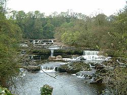
The first notable attraction near the Ure is the National Park Centre near Hawes; a few miles to the east the river goes over the beautiful Aysgarth Falls. The river then passes Middleham Castle and then the ruins of Jervaulx Abbey. Next the river passes through the market town of Masham which is home to the famous Theakston Brewery. The following attractions are Marmion Tower at West Tanfield and Norton Conyers.
The river then passes through the east edge of the historic City of Ripon, where it is joined by the River Skell. The river then flows past Newby Hall and the ancient monuments known as the Devil's Arrows. The Ure is bridged by the A1(M) motorway just to the west of the town of Boroughbridge.
To the east of Boroughbridge, the Ure is joined by the River Swale. About 6 miles downstream of this confluence, at Cuddy Shaw Reach near Linton-on-Ouse, the river changes its name to the River Ouse.
List of settlements on the River Ure
- from source
- Hawes
- Bainbridge
- Worton
- Aysgarth
- Wensley
- Middleham
- Masham
- Mickley
- West Tanfield
- Nunwick
- Hutton Conyers
- Ripon
- Roecliffe
- Boroughbridge
- Lower Dunsforth
- Aldwark
