Manger, Norway
Appearance
Manger kommune | |
|---|---|
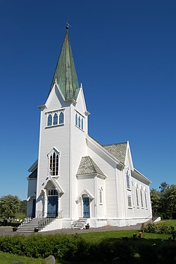
 Manger Church | |
| Country | Norway |
| County | Hordaland |
| District | Vestlandet |
| Municipality ID | NO-1261 |
| Adm. center | Manger |
| Population (1963) | |
| • Total | 1,328 |
| Created from | Manger formannskapsdistrikt in 1837 |
| Merged with | Herdla in 1871, Hjelme in 1910, Hordabø and Sæbø in 1924, and Radøy in 1964 |
Manger is a former municipality in Hordaland county, Norway.
It was created as Manger formannskapsdistrikt in 1837. On 1 January 1871 the district Herdla with 2,484 inhabitants split away to form a municipality of its own, and on 1 January 1910 the same thing happened with Hjelme. The splits left Manger with a population of 4,453. Manger was to be divided again on 1 July 1924, when the new municipalities Bø and Sæbø were created. After this final split Manger had a population of 1,426.
On 1 January 1964 Manger was merged with Hordabø and parts of Herdla, Sæbø, Lindås and Austrheim to form the new municipality Radøy. Prior to the merger Hordabø had 1,344 inhabitants.
References
- Dag Jukvam / Statistics Norway (1999). "Historisk oversikt over endringer i kommune- og fylkesinndelingen".
{{cite journal}}: Cite journal requires|journal=(help)
60°38′38″N 5°2′29″E / 60.64389°N 5.04139°E
