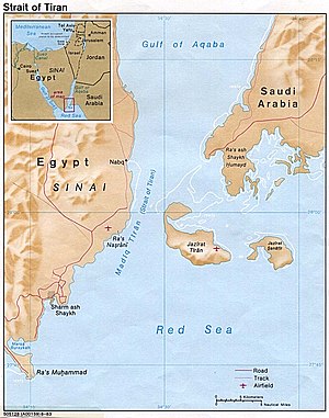
Straits of Tiran

The Straits of Tiran (Arabic: مضيق تيران Maḍīq Tīrān, Hebrew: מיצרי טיראן [Why is there no romanisation here? Are we all supposed to be fluent in Hebrew or something? I'd ask on the talk page, but it's protected.]), are the narrow sea passages, about 13 kilometres (8 mi) wide, between the Sinai and Arabian peninsulas which separate the Gulf of Aqaba from the Red Sea. It is named after Tiran Island located at its inflow, on which the Multinational Force and Observers has an observation post to monitor the compliance of Egypt in maintaining freedom of navigation of the straits as provided under the Israel-Egypt Peace Treaty.
Sanafir Island lies to the east of Tiran, southeast of the shallow strait between Tiran and Saudi Arabia.
Access to Jordan's only seaport of Aqaba and to Israel's only Indian Ocean seaport of Eilat is contingent upon passage through the Gulf of Aqaba, giving the Straits of Tiran strategic importance. Egypt's blockade of the Straits to Israeli ships and ships bound for Israel in 1956 and again in 1967 was a catalyst to the Suez Crisis in 1956 and the Six-Day War in 1967.[1] Despite this, according to Major General Indar Jit Rikhye, military adviser to the United Nations Secretary General, the accusation of a blockade was "questionable," pointing out that an Israeli-flagged ship had not passed through the straits in two years, and that "The U.A.R. [Egyptian] navy had searched a couple of ships after the establishment of the blockade and thereafter relaxed its implementation."[2]
International documents inconsistently refer to both the "Straits of Tiran" and the "Strait of Tiran". There are several passages formed by the islands between Egypt and Saudi Arabia. The westernmost strait, between Egypt and the island of Tiran, overlooked by the Egyptian city Sharm el-Sheikh is the "Strait of Tiran". It has two passages deep enough to be navigable by large ships. The Enterprise passage, 290 metres (950 ft) deep, is adjacent to the Egyptian side, while the 73-metre (240 ft) deep Grafton passage, surrounded by shallows, is to the east, nearer to the island of Tiran. To the east of Tiran, between it and Saudi Arabia, the other strait has reefs and shallows with a single channel 16 metres (52 ft) deep.[3]
A project to build a 15-kilometre (9.3 mi) bridge across the straits, linking Egypt and Saudi Arabia, is under consideration by the Egyptian government (see Saudi–Egypt Causeway).[4]
See also
References
- ^ Oren, Michael B. (2002). Six Days of War: June 1967 and the Making of the Modern Middle East. Oxford: Oxford University Press. ISBN 0195151747.
- ^ Rikhye, Indar Jit (1980). The Sinai Blunder: Withdrawal of the United Nations Emergency Force Leading to the Six-Day War of June 1967. London: Rutledge. ISBN 0714631361.
- ^
Carl F. Salans (1968). "Gulf of Aqaba and Strait of Tiran: Troubled Waters". United States Naval Institute Proceedings. 94 (56).
{{cite journal}}: Cite has empty unknown parameters:|laysource=,|laydate=,|laysummary=, and|quotes=(help); Unknown parameter|month=ignored (help) - ^ Najla Moussa. "Bridge connecting Egypt, Saudi Arabia considered". Daily News Egypt. March 2, 2006.
