
Tarrazú (canton)

Tarrazú is the name of the 5th canton in the province of San José in Costa Rica. The canton covers an area of 297.50 km²,[1] and has a population of 15,142.[2] The capital city of the canton is San Marcos.
The Río Pirrís (also known as Río Parrita) establishes much of the northern boundary of the three-pronged canton, which reaches south across the Coastal Mountain Range to its border with the canton of Aguirre in Puntarenas Province.
Districts
The canton of Tarrazú is subdivided into three districts (distritos):[3]
History
The canton was established by a legislative decree of August 7, 1868. It was part of the Desamparados canton by that time.

Geography
Tarrazu is located about 70 kilometers south of the Capital San Jose, in a pristine valley surrounded by mountains that are part of the Talamanca Sierra in southern Costa Rica. Downtown San Marcos is 1350 meters above sea level but is surrounded by peaks as high as 3000 meters above sea level.
Highland coffee is the main source of income of local people. However, tourism, and Avocado are of increased importance. During the months of December, January and February, population increases three-fold due to harvest time. San Marcos, the biggest town in the region, has become the center of economic activity. More recently the Costa Rican Institute of Electricity has invested millions of dollars in the Pirris Hydro Dam, scheduled to start generating energy by March 2011. The Hydro Dam is now the highest structure of its kind in Central America and will be key to the economic development of the region, not only in the highlands but the coastal regions of Quepos and Parrita.
Following, there is a gallery of pictures that best represent this lesser known part of Costa Rica.
-
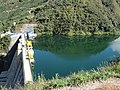
Pirris Hydro Dam, Tarrazu, near Quepos port, Costa Rica
-
 Pirris Hydro Dam, Tarrazu, Costa Rica
 -
 Pirris Hydro Dam, Tarrazu, Costa Rica
 -
 Pirris Hydro Dam, Tarrazu, Costa Rica
 -
 Pirris Hydro Dam, Tarrazu, Costa Rica
 -
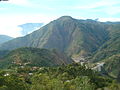
 Concepcion Mountain, Tarrazu Highlands in southern Costa Rica, near Quepos Port
 -
 Another Pirris Hydro Dam picture in Tarrazu, as of March 2011
 -
 Pirris Hydro Dam, Tarrazu, Costa Rica
 -
 Pirris Hydro Dam in the Tarrazu highlands, as of January 2011
 -
 Pirris Hydro Dam under construction in the Tarrazu highlands, few miles from Port Quepos
 -
 Pirris Hydro Electric Dam - energy generating station - near Quepos Costa Rica
 -
 Coffee farm in La Laguna Tarrazu, Costa Rica
 -
 Coffee plantations in the highlands of San Marcos de Tarrazu Costa Rica
 -
 Sunrise in San Marcos de Tarrazu Costa Rica
 -
 Coffee cherries under the sun - San Marcos de Tarrazu Costa Rica
 -
 Sundrying Highland coffee in Tarrazu, Costa Rica
 -
 Local coffee picker in a farm near San Marcos Tarrazu, Costa Rica
 -
 Coffee farms in San Marcos Tarrazu
 -
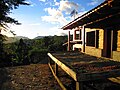
 Small farm in the Highlands of Tarrazu, Southern Costa Rica
 -
 Coffee fields in the mountains of Tarrazu Costa Rica, near Quepos
 -
 Highland coffee fields in Tarrazu Costa Rica
 -
 Ox Cart in Downtown San Marcos Tarrazu Costa Rica
 -
 Sunset at Alto Quepos Tarrazu Costa Rica
 -
Late afternoon Tarrazu mountains near Quepos Costa Rica
-
 Mountains in the Quepos Tarrazu region in Costa Rica
 -
 Forested hills in Tarrazu, near the port of Quepos in Southern Costa Rica
 -
 Forests near Quepos Costa Rica in the Tarrazu mountains
 -
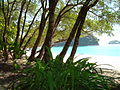 Quepos Beach - a short distance from the mountains of Tarrazu in Costa Rica
 -
 Shack in the forest near Quepos Costa Rica
 -
 Tourists enjoying the view in the highlands above Quepos Costa Rica, near Tarrazu


References
- ^ Instituto Geográfico Nacional (IGN), 2001.
- ^ Estimates of Instituto Nacional de Estadística y Censos (INEC), May 2003.
- ^ "División Territorial Administrativa de Costa Rica" (PDF) (in Spanish). Instituto de Fomento y Asesoria Municipal (IFAM). 5 May 2009.