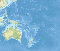
2013 Solomon Islands earthquake
| UTC time | ?? |
|---|---|
| Magnitude | Mw 8.0 |
| Epicenter | 10°44′16″S 165°08′16″E / 10.7377°S 165.1378°E |
| Type | Earthquake |
| Areas affected | Solomon Islands, New Caledonia, Vanuatu |
| Casualties | 5 dead [1] [2] |
This article documents a current event. Information may change rapidly as the event progresses, and initial news reports may be unreliable. The latest updates to this article may not reflect the most current information. |
On 6 February, 2013, at 12:12 p.m. an earthquake struck the Solomon Islands, located in the south Pacific Ocean.[3] It struck at a depth of 28.7 km (17.8 mi),[4] and the epicenter was about 5 km (3 mi) offshore the Santa Cruz Islands in the Solomons.[5] The earthquake occurred due to the interaction between the Australian Plate and the Pacific Plate, and was preceded by dozens of foreshocks in the region.[6] The intensity was estimated at M8.0 on the Moment magnitude scale[7]. There were at least two aftershocks that measured at least M6.0,[3] including one measuring M6.6.[4] The Pacific Tsunami Warning Center issued a tsunami warning for the Solomon Islands, Papua New Guinea, and several other islands in the region, and the agency issued a tsunami watch for Australia, New Zealand, and eastern Indonesia.[3][5] It produced a tsunami measuring 0.91 m (3 ft) at Lata, Solomon Islands.[5][3] Smaller tsunamis of 11 cm (4.3 in) and 50 cm (20 in) were reported in Vanuatu and New Caledonia, respectively.[8]
In Honiara, the capital of the Solomon Islands, residents evacuated to higher ground,[5] causing traffic jams.[8] Local news agencies reported that several villages were destroyed.[5] Houses were flooded in eastern portions of Temotu Province, but there were no initial reports of serious injuries.[4] On Santa Cruz Island, 1.5 m (4.9 ft) waves damaged 50 buildings.[9] In Lata, the tsunami damaged the airport and other low-lying areas.[10] Officials in Noumea ordered residents to evacuate along the eastern coast of New Caledonia and nearby Loyalty Islands.[11]
See also
References
- ^ http://www.bbc.co.uk/news/world-asia-21347496
- ^ http://edition.cnn.com/2013/02/05/world/asia/solomon-islands-quake/index.html?hpt=hp_t2
- ^ a b c d Kaylene Hong (2013-02-05). "Magnitude 8 Quake Strikes Off Santa Cruz Islands". Wall Street Journal. Retrieved 2013-02-05.
- ^ a b c "Powerful earthquake strikes off Solomon Islands". BBC. 2013-02-05. Retrieved 2013-02-05.
- ^ a b c d e "Tsunami alert after Solomon Islands earthquake". The Guardian. 2013-02-05. Retrieved 2013-02-05.
- ^ M8.0 - Santa Cruz Islands (Report). United States Geological Survey. Retrieved 2013-02-05.
- ^ M8.0 - Santa Cruz Islands (Report). United States Geological Survey. Retrieved 2013-02-06.
- ^ a b "Solomons quake triggers tsunami, destroys villages". ABC Australia. 2013-02-05. Retrieved 2013-02-05.
- ^ "Tsunami damages dozens of homes in Solomon Islands". USAToday.com. Associated Press. 2013-02-05. Retrieved 2013-02-05.
- ^ "Fears for villages after major quake hits near Solomons". Sydney Morning Herald. 2013-02-06. Retrieved 2013-02-05.
- ^ "Powerful quake strikes in South Pacific, sparks tsunami". CNN. 2013-02-05. Retrieved 2013-02-05.

