
Joucas
Joucas | |
|---|---|
 | |
Location of Joucas  | |
| Country | France |
| Region | Provence-Alpes-Côte d'Azur |
| Department | Vaucluse |
| Arrondissement | Apt |
| Canton | Gordes |
| Government | |
| • Mayor (2001–2008) | Lucien Aubert |
| Area 1 | 8.29 km2 (3.20 sq mi) |
| Population (2006) | 324 |
| • Density | 39/km2 (100/sq mi) |
| Time zone | UTC+01:00 (CET) |
| • Summer (DST) | UTC+02:00 (CEST) |
| INSEE/Postal code | 84057 /84220 |
| Elevation | 178–447 m (584–1,467 ft) (avg. 263 m or 863 ft) |
| 1 French Land Register data, which excludes lakes, ponds, glaciers > 1 km2 (0.386 sq mi or 247 acres) and river estuaries. | |
Joucas (Jocàs in Occitan) is a commune in the Vaucluse department in the Provence-Alpes-Côte d'Azur region in southeastern France. The town is located on the perimeter of the Parc naturel régional du Luberon.
Geography
Located between two of the "most beautiful villages in France," Gordes and Roussillon, Joucas is a small hilltop village of Monts de Vaucluse. From the village you can see the surrounding plain and ochre hills of Roussillon. Like most of the hilltop villages of the region, this good visibility, and therefore the ability to see enemies approaching from far away, was one of the reasons for choosing the location of the village.
Démography
| Year | Pop. | ±% |
|---|---|---|
| 1793 | 303 | — |
| 1800 | 299 | −1.3% |
| 1806 | 310 | +3.7% |
| 1821 | 308 | −0.6% |
| 1831 | 393 | +27.6% |
| 1836 | 390 | −0.8% |
| 1841 | 364 | −6.7% |
| 1846 | 391 | +7.4% |
| 1851 | 455 | +16.4% |
| 1856 | 437 | −4.0% |
| 1861 | 435 | −0.5% |
| 1866 | 398 | −8.5% |
| 1872 | 380 | −4.5% |
| 1876 | 397 | +4.5% |
| 1881 | 311 | −21.7% |
| 1886 | 307 | −1.3% |
| 1891 | 265 | −13.7% |
| 1896 | 232 | −12.5% |
| 1901 | 219 | −5.6% |
| 1906 | 206 | −5.9% |
| 1911 | 212 | +2.9% |
| 1921 | 181 | −14.6% |
| 1926 | 169 | −6.6% |
| 1931 | 175 | +3.6% |
| 1936 | 180 | +2.9% |
| 1946 | 195 | +8.3% |
| 1954 | 173 | −11.3% |
| 1962 | 163 | −5.8% |
| 1968 | 201 | +23.3% |
| 1975 | 204 | +1.5% |
| 1982 | 210 | +2.9% |
| 1990 | 258 | +22.9% |
| 1999 | 317 | +22.9% |
| 2006 | 315 | −0.6% |
| From the year 1962 on: population without double counting Source: INSEE[1] | ||
Evolution of population graph between 1794 to 2006
Places to see
-
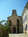 Joucas church
 -
 inside the church
 -
 old wash house


See also
References
This Vaucluse geographical article is a stub. You can help Wikipedia by expanding it. |