Lys (river)
| Lys | |
|---|---|
 | |
 | |
| Physical characteristics | |
| Mouth | Scheldt 51°3′18″N 3°44′3″E / 51.05500°N 3.73417°E |
| Length | 202 km (126 mi) |

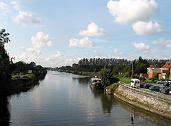
The Leie (Dutch) or Lys (French) is a river in France and Belgium, and a left tributary of the Scheldt. Its source is in Pas-de-Calais, France, and it flows into the river Scheldt in Ghent, Belgium. Its total length is 202 kilometres (126 mi).
It is a very polluted river due to the high density of population and industry in the farmost North of France and in Belgium. Historically, the Leie valley was known for the spinning and weaving of flax. The region of the Leie (between Deinze and Ghent) used to be known as a favourite place for numerous painters in the first half of the twentieth century.
The source of the Leie is in the village Lisbourg (Liegesboort in Dutch), east of Fruges or Frusje, in the Pas-de-Calais department of France. It flows generally northeast through the following departments of France, provinces of Belgium and towns and municipalities:
- Pas-de-Calais (F): Thérouanne, Aire-sur-la-Lys
- Nord (F): Merville, Armentières, Halluin
- Hainaut (B): Comines-Warneton
- West Flanders (B): Menen, Wevelgem, Kortrijk, Waregem, Wervik
- East Flanders (B): Zulte, Deinze, Ghent
The river Leie was the location of three battles between the Allies and the German Army. During the First World War in 1918 the location was the scene of the First Battle of the Lys, which was part of the German Spring Offensive, and later that year of the Second Battle of the Lys, which was part of the Allies' Hundred Days Offensive. During the Second World War the Battle of the Lys was part of the 1940 Nazi-German offensive in Flanders towards the English Channel.
External links
- International rivers of Europe
- Scheldt basin
- Rivers of Belgium
- Rivers of France
- Rivers of Nord-Pas-de-Calais
- Rivers of Nord (French department)
- Rivers of the Pas-de-Calais
- Rivers of Flanders
- Rivers of Wallonia
- Rivers of East Flanders
- Rivers of West Flanders
- Rivers of Hainaut (province)
- County of Flanders
- Belgium geography stubs
- Hauts-de-France geography stubs
